1950s Wanchai | Gwulo: Old Hong Kong

1950s Wanchai

1950s Wanchai
Tags: 

Received via email.

Date picture taken (may be approximate): 
Sunday, January 1, 1950
Connections: 

Comments

Hi there,

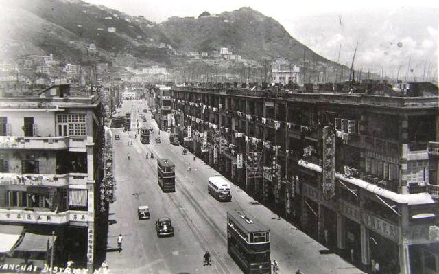
This photo actually showed the Hennessy Road. I will send a marked-up photo to illustrate.

The side street running in the foreground near the edge is Canal Road West. I recognized this owing to a Historical Landmark in the Foreground by the right, the Tai Sam Yuen Restaurant, which was still there in the late the early 70's. See also the tram turning west at Tin Lok Lane and Hennessy.

T

It has been a month since my writing to Hong Kong Tramways and I receive no reply from them.  I can't give any solid proof except a few readings.  To anyone who happens to read my posting "Tram Direction", please forgive my reckless action. 

The photo was taken from a building in Hennessy Road.

Have been trying to follow-up the question of the tram direction for some time. Noted from a hard cover book titled "Early Hong Kong Tramways" by Cheng Po Hung that the turn into Happy Valley and to the former tram depot on Sharp St (present day Times Square) was originally via Canal Rd East. The change to Percival St came about in the 1950s (exact date not given). Trams leaving Happy Valley still use the current route via Morrison Hill Rd and Tin Lok Lane.

According to the Hong Kong Tramways website, tram operations commenced on 30 July 1904 and the earliest tram depot was in the Bowrington Road/Canal Road area. It was not until the early 1920s, that the tram depot in Russell Street was built. The following information was found through the public archives: a) the Happy Valley branch line was a dual line that operated between Morrison Hill Rd (near the junction with Tin Lok Lane) and the Happy Valley Racecourse Grandstand and b) a loop line operated from Praya East into Bowrington Rd, thence westwards along Sharp St to the junction with Morrison Hill Rd and joining Praya East via Tin Lok Lane. On 8 May 1913, Government approved the construction of a single line between Wong Nei Chong Village and the Happy Valley Racecourse Grandstand. On 19 January 1923, the tramline from Wong Nei Chong Village was extended along Wong Nei Chong Rd (eastern side of Happy Valley) and Leighton Hill Rd to connect with the tramline at Morrison Hill Rd. (It is assumed during this period that the dual line from Morrison Hill to the Racecourse reverted to a single line). During the period 1925-1928, single tramlines were constructed between: a) Praya East and Percival St to connect with the Happy Valley line and Russel St tram depot and b) Praya East and Bowrington Canal Rd East to connect with Leighton Hill Rd and Russel St tram depot With the completion of the Praya East (Wanchai) Reclamation in 1930, dual tramlines were built on Hennessy Rd and the bridge (Ngo Keng Kiu) over Bowrington Canal. From the above, it appears that the Percival St southbound route to Happy Valley via Leighton Hill and Wong Nei Chong Roads has been use since the mid 1920s.

Moddsey's mention of Ngo Keng Kiu reminded me I've heard MrsB use the term several times in the past - either when telling a minibus driver where to stop, or arranging where to meet someone. It's used to describe the point where the Canal Road Flyover crosses Hennessy Rd:

Ngo Keng Kiu literally means "Goose Neck Bridge". Many people think it refers to the flyover, as that seems to be the only bridge around. In fact the name dates back to when the area bounded by Canal Rd East & West was still a canal, crossed at Hennessy Road by Bowrington Bridge. The Chinese name for the bridge was Ngo Keng Kiu.

I'd read one explanation that the slender bridge was supposed to be reminiscent of a Goose's Neck. But Wikipedia has quite a different explanation under the entry for Canal Road:

Before urban development the area was the estuary of a river named "Wong Nai Chung", which looked like the neck of a goose. The 4th Governor of Hong Kong, John Bowring built Bowrington (or Bowring City) around the estuary. Bowrington Canal was built as the extension of Wong Nai Chung and the long and narrow canal was known as and thus known as Ngo Keng Kan (鵝頸澗, lit. goose neck stream). The landmark Bowrington Bridge built in 1861 across the canal was known as Ngo Keng Kiu (鵝頸橋, lit. goose neck bridge).

Other notes:

  • If you've walked around the area today, you've probably noticed the old ladies under the flyover, hitting paper cutouts with old shoes. Here's a good explanation of what they are doing.
  • The Hong Kong Public library has several old photos of the Bowrington Canal, and note that originally it was 90 feet wide. To view the photos, go to the search page, tick the "photo" checkbox, type "canal" as the keyword text, and click the search button.

MrB

Thanks moddsey & MrB for the correction regarding the tram direction.

By the way, I obtained the information from two books.

Regards,

Isdl

from the 1860s and 1910s.

Received via email:

There is a 1930s photo in the HK Public Library collection (tick 'photo', type 'percival', and click search). Here is a 1950s photo.

1. Official Date

30 July 1904 was an official ceremony however the entire service was by 13 August.

2. Happy Valley routes

Initially the Happy Valley trams came in along Bowrington Road and out by Tin Lok Lane joining at Morrison Hill Road where it ran double track to the terminus. Afterwards the line was extended single track along Wong Nei Chong Road. The full loop was completed in 1922 and the double track along Morrison Hill Road was made single. Happy Valley trams then turned in Canal Road East (when the depot entrance at Russell Street) and changed to Percival Street (when the depot extension ended).

Regards, Joseph


Hi T:

  You are right. The photo is looking west on Hennessy road at the intersection with Canal Road. Besides the Tai Sam Yuen on the right,

you can see another restaurant "英男茶樓" on the left at the intersection.  The address of the latter is 418-428 Hennessy Road as recorded in this book here:

https://books.google.de/books?id=E0oREAAAQBAJ&pg=PA349&lpg=PA349&dq=%E8%...