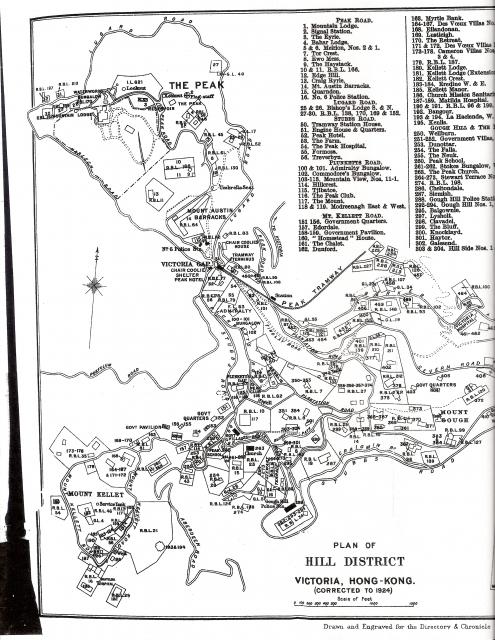
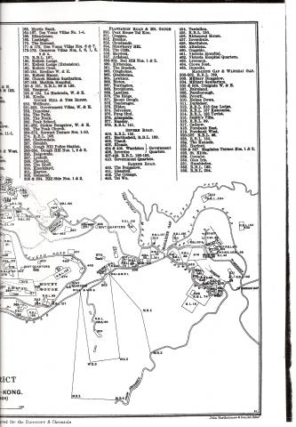
The Peak - Map 1924 (1 of 2)
Primary tabs

Submitted by annelisec
Date picture taken (may be approximate):
Tuesday, January 1, 1924
Connections:
- The Peak - Map 1924 (1 of 2) shows Place Eredine - RBL 56 [????- ]
- The Peak - Map 1924 (1 of 2) shows Place The Peak Church / Peak Chapel [1883-c.1958]
- The Peak - Map 1924 (1 of 2) shows Place Red Hill 1 & 2, 358-359 The Peak [c.1898-????]
- The Peak - Map 1924 (1 of 2) shows Place RBL 34, 1,2 & 3 Gough Hill. 292, 293 & 294 The Peak, 103, 104 & 104A The Peak [c.1888-c.1923]


Comments
Dear David, I was wondering
Dear David,
I was wondering if I could have the PDF file for this map?
I can help type a page of the Juror's List if it would be of any help.
Regards,
Voidian
British Naval Hospital, The Peak
Can anyone identify the position of the British Naval Hospital on the Peak. I believe it was somewhere just across the "Jardines Bridge" - my mother was the first 'female' baby born there in 1932! I am not sure, but I think there may be part of the original plinth the hospital was built on, still existing?
Re War Memorial Hospital
You may be referring to the WMH on Mount Kellett Road. Please see: http://gwulo.com/war-memorial-hospital
The link to the full scan for
The link to the full scan for this image is
http://gwulo.com/sites/gwulo.com/files/images/scan0029.jpg
Many thanks, annelisec. It
Many thanks, annelisec.
It seems that the link you provided is half of the map, would you have the other half?
Your help is much appreciated.
http://gwulo.com/sites/gwulo.
http://gwulo.com/sites/gwulo.com/files/images/scan0028.jpg
1960 Changes to Road Names on the Peak
China Mail 7 July 1960
With effect from 1 September 1960, the following roads were renamed:
a)Stubbs Road from Wanchai Gap to the Upper Peak Tram Station will be known as Peak Road;
b) Existing Peak Road from Upper Peak Tram Station to Victoria Peak will be known as Mount Austin Road;
c) Old Peak Road is the new name for the road from Robinson Road to Victoria Gap;
d) Aberdeen Road for its entire length will be known as Peel Rise and
e)Tanderagee Road will be known as Pollock's Path.
Peel Rise
I wonder why they named Aberdeen Street after Governor William Peel thirty years or so after he retired, unless part of it was already named that.
Tanderagree Road was obviously named after the house at the end of it. http://en.wikipedia.org/wiki/Henry_Pollock died in 1953.
Text from map
Peak Road.
1. Mountain lodge.
2. Signal Station.
3. The Eyrie.
4. Bahar Lodge.
5 & 6. Meirion, Nos. 2 & 1.
7. Tor Crest.
8. Ewo Mess.
9. The Haystack.
10 & 11. R.B.L. 166.
12. Edge Hill.
13. Craig Ryrie.
14. Mt. Austin Barracks.
15. Quarndon.
16. No. 6 Police Station.
LUGARD ROAD.
25 & 26. Bishop’s Lodge S. & N. 27-30. R.B.L. 138, 170, 169 & 152. Stubbs Road.
50. Tramway Station House.
51. Engine House & Quarters.
52. Peak Hotel.
53. The Farm.
54. The Peak Hospital.
55. Formosa.
56. Treverbyn.
Plunketts Road.
100 & 101. Admiralty Bungalow.
102. Commodore’s Bungalow.
103-113. Mountain View, Nos, 11-1.
114. Hillcrest.
115. Tjibatoe.
116. The Peak Club.
117. The Mount.
118 & 119. Modreenagh East & West.
Mt. Kellett road.
151 156. Government Quarters.
157. Edordale.
158-159. Government Pavilion.
160. “Homestead” House.
161. The Chalet.
162. Dunford.
163. Myrtle Bank.
164-167. Des Voeux Villas No. 1-4.
168. Eilandonan.
169. Lustlelgh.
170. The Retreat.
171 & 172. Des Voeux Villas Nos. 6 & 7. 173-178. Cameron Villas Nob, 5, 6, 1, 2, 3 & 4.
179. R.B.L. 187.
180. Kellett Lodge.
181. Kellett Lodge (Extension).
182. Kellett Crest.
183-184. Eredine W. & E.
185. Kellett Manor.
186. Church Mission Sanitarium.
187-189. Matilda Hospital.
190 & 191. R.B.L. 96 & 199.
192. Bangour.
193 & 194. La Hacienda, W. & E.
195. Kenlis.
Gough Hill & The Bluff.
250. Wellburn.
251-252. Government Villas, W. & E.
253. Dunottar.
254. The Falls.
255. The Neuk.
260. Peak School.
261-262. Stokes Bungalow, W. & E.
263. The Peak Church.
264-273. Stewart Terrace Nos. 1-10.
274. R.B.L. 198.
286. Cheltondale.
287. Slemish.
288. Gough Hill Police Station.
292-294. Gough Hill Nos. 1, 2 & 3.
295. Balgownie.
297. Lysholt.
298. Clavadel.
299. The Bluff.
300. Knocklayd.
301. Haytor.
302. Galesend.
303 & 304. Hill Side Nos. 1 & 2.
Plantation Road & Mt. Gough
350. Peak House Tai Koo.
351. Creggan.
352. Brentor.
353. Cloudlands.
354. Strawberry Hill.
355. The Cliffs.
356. Mayfield.
357. Ardsheal.
358-359. Red Hill Nos. 1 & 2.
360. Kirkendoa.
361. The Bracket.
362. Cragholme.
363. Glasbheinn.
364. Lewknor.
366. Bicton.
367. Burrington.
368. Brockhurst.
369. Landless.
370. The Ridge.
371. Mount Gough.
372. Tanderagee.
373. Hilden.
374. Belvedere.
375. Fung Shui.
376. Abergeldie.
377. Hazeley.
378. R.B.L. 151.
Severn road.
400. R.B.L. 155.
401. Martinsfield, R.B.L. 139.
402. Tjandi.
403. Kinsale. )
404 & 405. Warriston )> Government 406. Inverdee ) Quarters.
407-409. R.B.L. 190-192.
410. Government Quarters.
Barker Road.
450. The Bungalow.
451. Glensheil,
452. The Cottage.
453. Tai Wo.
454. Tantallon.
455. R.B.L. 150.
456. Richmond House.
457. Inverdruie.
458. Martinhoe.
459. Altadena.
460. Cragside.
461. Victoria Hospital.
462. Victoria Hospital Quarters.
463. Lyeemun.
464. Crows Nest.
465. Dunedin.
Magazine Gap & Wanchai Gap.
500-502. R.B.L. 189.
503. Military Bungalow.
504. Military Sanitarium.
505 & 506. Craigmin W. & E.
507. Fairyland.
508. Farnborough.
509. Peveril.
510. Holme Down.
511. Durisdeer.
512. R.B.L. 216 Gap Lodge.
513. R.B.L. 157 Katoomba.
514. R.B.L. 195 Teviot.
515. Smith's Villa.
516. R.B.L. 39.
517. Cadzow.
518. Forebank East.
519. Forebank West.
520-522. R.B.L. 66.
523. R.B.L. 154.
524. The Kennels.
525. Harford.
526 & 527. Magdalen Terrace Nos. 1 & 2.
528. St. Kilda.
529. Coombe.
530. Glen Iris.
531. Hambleden.
532. R.B.L. 193.
533. R.B.L. 204.