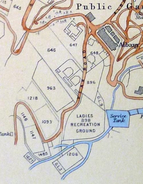
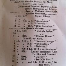
Cropped from map in UK National archive collection dated to 1903, their ref: MFQ 1/1363.
Map of Peak Road
Primary tabs

Submitted by Admin
Date picture taken (may be approximate):
Thursday, January 1, 1903
Gallery:
Connections:
- Map of Peak Road shows Place "Gardener House" - Residence of the Lord Deputy of the Botanical Gardens - 1860s [????-????]
- Map of Peak Road shows Place "Upper Albany" - 1860s [????-????]
- Map of Peak Road shows Place Kurrahjeen [1865-????]
- Map of Peak Road shows Place Devonia - 1860s [????-????]
- Map of Peak Road shows Place Blue Bungalow - IL 646 [1865-1959]
- Map of Peak Road shows Place Victoria Lodge - 1890s [????-????]
- Map of Peak Road shows Place Charter House - IL 1218 [1885-1958]
- Map of Peak Road shows Place Norman Cottage - 1880 [????-????]
- Map of Peak Road shows Place Stillingflete - 1880s [????-????]
- Map of Peak Road shows Place Belle Vue (or Bellevue) - 1860s [????-????]
- Map of Peak Road shows Place Derrington - IL 896 [1887-1930]
- Map of Peak Road shows Place Ladies Recreation Club (LRC) - IL 898 [1883- ]
- Map of Peak Road shows Place Clovelly - 1920s [????-????]
- Map of Peak Road shows Place Ian Mor [????-????]
- Map of Peak Road shows Place Luginsland - 1880s [????-????]
- Map of Peak Road shows Place St. Andrew's / Inverugie - 1890s [????-????]


