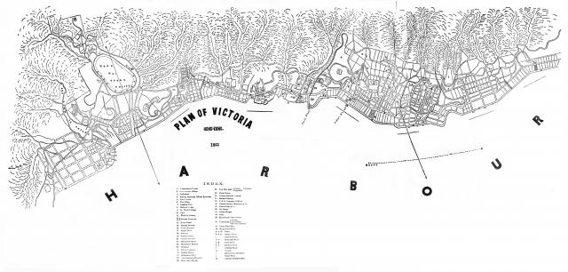
Here goes my second attempt at adding maps for David's new map project. The source this time is the 1867 edition of the Chronicle & Directory of China. Japan & Corea etc.,etc. Note that there are some minor imperfections in the street alignments in the area adjacent to Taiping Shan, Union Chapel & Hollywood Road ( marked as "37" & "D" respectively in the Index) . These errors (arising from page joints or paper folds) were present in the original microfilm reader printouts from which I have stitched this map together. Readers also note that the cartographer has not aligned this map in the conventional North facing direction.


Comments
Index
Another good addition, thank you. Here's the index to help people find it when searching by text:
INDEX.
1866 Map
Tymon has found this map was also used in the 1867 edition of "The Treaty Ports of China and Japan. A Complete Guide to the Open Ports of those Countries, together with Peking, Yedo, Hongkong and Macao" It has been reprinted by Cambridge Press, and they have the maps (colour, hand-tinted) available for download in their "resources" section. The Hong Kong map is "Map 003: Map of Victoria", on the second page of the resources:
http://www.cambridge.org/hk/academic/subjects/history/east-asian-history...