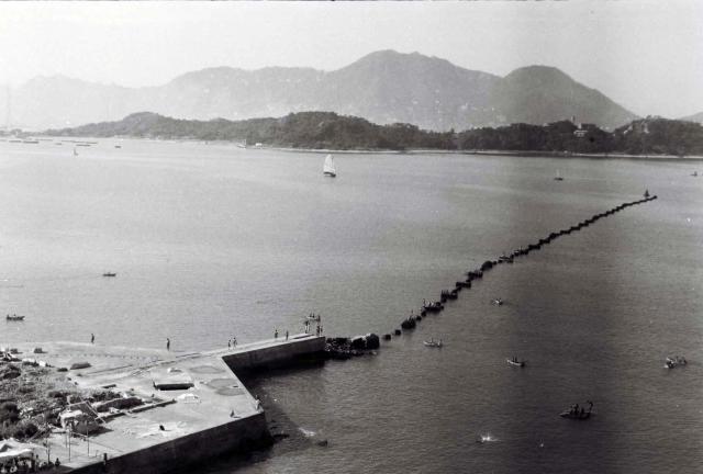
Clues as to the location might be (a) the smal hired(?) rowing boats, (b) the strange line of rocks(?) with people bathing and diving from them, (c) what looks like a buoy at the far end of the rocks and (d) the large area of concrete at the bottom left. This appeas to have the remains of military(?) structures on it and right in the bottom left corner there is a temporary shelter with people standing under it - waiting for a ferry perhaps? Tolo Harbour? Lots of questions and clues. Any thoughts? (Andrew S)
Rowing boats
Primary tabs

Submitted by Andrew Suddaby
Date picture taken (may be approximate):
Tuesday, January 1, 1952
Gallery:
Connections:
- Rowing boats shows Place Lai Chi Kok pier [????-????]


Comments
Harbour Boom
Hong Kong Island is in the background. Stonecutters Island is the elongated island in the middle. We had seen previously a harbour boom extending from Green Island. Perhaps the continuation of the boom towards Lai Chi Kok.
Update: China Mail 23 August 1949
The western part of the Hong Kong Harbour will shortly be completlely sealed except for two 500-yard gaps. As a precaution of movement into Hong Kong of undesirable elements and illegal goods, two light booms will be laid on the western harbour limits. One will be placed between Green Island and Stonecutters Island and the other between Stonecutters Island and the Torpedo Firing Pier at Lai Chi Kok.
concrete pier
you can see this very pier on the 1952 map on the west side of lai Chi Kok bay. It's quite distinctive.
HKGRO Reference
Noted that it was referred to as the Lai Chi Kok Torpedo Range prior to WWII.
Thank you Moddsey. My
Thank you Moddsey and Phil. My attention was concentrated on the more in focus line of rocks closer inshore. Further out I see that they appear to be more regular in shape and, as you suggest, are very likely to be the floating ‘drums’ supporting a boom, and the buoy would fit in with that explanation. Regards Andrew.