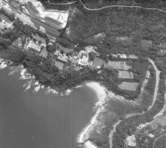
Aerial view of Tai Tam, circa 1970
Primary tabs

Submitted by philk
Date picture taken (may be approximate):
Thursday, January 1, 1970
Gallery:
Connections:
- Aerial view of Tai Tam, circa 1970 shows Place Tai Tam Bay [????- ]
- Aerial view of Tai Tam, circa 1970 shows Place Pillbox 029, Tai Tam Bay near American Club [1939- ]
- Aerial view of Tai Tam, circa 1970 shows Place South Cliff - RBL 147 [1920-1988]
- Aerial view of Tai Tam, circa 1970 shows Place Longview - RBL 442 [1950-2010]
- Aerial view of Tai Tam, circa 1970 shows Place Faber Court [1975- ]
- Aerial view of Tai Tam, circa 1970 shows Place Stanley Lodge - RBL 146 [1925-1982]
- Aerial view of Tai Tam, circa 1970 shows Place Tytam Villa - RBL 145 [1920-1982]
- Aerial view of Tai Tam, circa 1970 shows Place Palm Villa - RBL 144 [1920-1982]


Comments
Aerial view of Tai Tam & (PB 29)
This was part of the route I took a few weeks ago when we climbed along to Stanley.
You can see PB29 if you follow the path up from the jetty in front of the American Club (The rectangle to the left of the path). This Picture is better quality than on Google Earth.
Thanks David for the Gwulo information.
Pillbox 29
Thanks Craig, I've added the PB to the "places shown" for the photo.
I believe this is a Govt aerial survey photo, hence the quality, but because I didn't get it from them I have no idea the year it was taken. Needless to say it was before the American Club was built in the early 80's (1984?).
Cheers
Phil
Can you please add this photo
Can you please add this photo to the following "places"
Rosecliff
Longview
Faber Court
Stanley Lodge
Tytam Villa
Palm Villa
since the American Club was not built yet, perhaps it should not be listed under "places seen in this photo"
Thanks