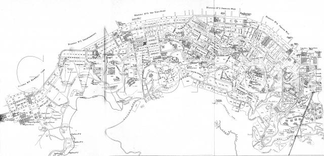
Click here to see a copy of this map overlayed on a present-day map of Hong Kong, with markers for all the Places we've got more information about.
The map appeared in "Hong Kong, A Brief History and Guide of Hongkong and the New Territories", published by Kelly & Walsh, Ltd in 1924. There's a copy available in the local Royal Asiatic Society's library.
It appears that Kelly & Walsh licensed a copy of the map 'Plan of the City of Victoria", prepared in London by Stanfords (cf. an 1889 version of the same map shown in Plate 3-2, Mapping Hong Kong).


Comments
Where a lot number is shown
Where a lot number is shown ie 2308,2139,2363 on May Road, does this mean that a residence has already been constructed on the site?. Tks
re: does this mean that a residence...
Sorry, I'm not sure if whoever drew the original map included all lots, or only those that had been built on.
Regards, David
PS I've fixed the 'click here' link above.
No.33 Mosque Junction
Wah Yan College (Hong Kong), founded by Peter Tsui, commenced on16th December 1919 at No.60 Hollywood Road (still standing today). It quickly expanded to No.54A Peel Street and No.33 Mosque Junction. The school consolidated its premises at the old St. Joseph's College at No.2 Robinson Road in 1921.
I wonder what is the location and if there is a picture of No.33 Mosque Junction in 1920.
We've got Places for 60
We've got Places for 60 Hollywood Road (http://gwulo.com/node/2226) and St Joseph's Building (http://gwulo.com/node/4107), and I've just added Places for 33 Mosque Junction (http://gwulo.com/node/19182) and 54A Peel Street (http://gwulo.com/node/19183).
Regards, David