Received via email:
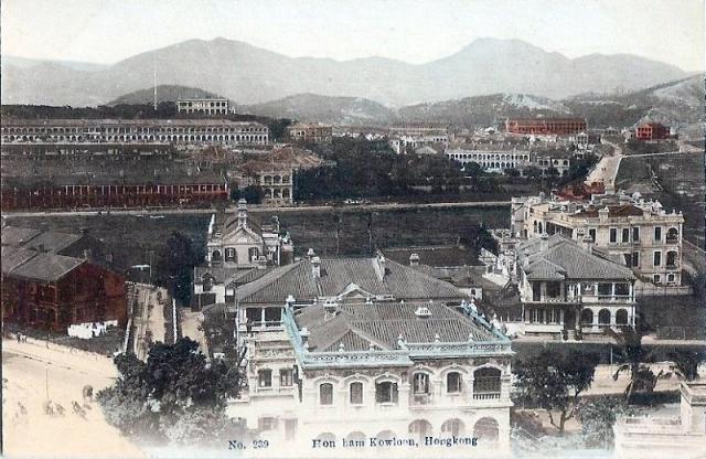
The postcard most probably was taken from Signal Hill looking down onto Mody Rd and looking north across the side streets that connect Chatham Rd with Nathan Rd.
Knutsford Terrace is the long row of houses on the top left. Chatham Rd is on the extreme right with the road leading up to Gun Club Hill Barracks visible just off to the right turning road leading to Hung Hom.
The long road in the middle looks like Granville Rd. The mansion on the flickr set would most probably have been located south of Granville (probably Cameron) and may well be one of the houses seen on the right.


Comments
Mansion on Chatham Rd.
Mansion on Chatham Rd
Another email:
Mansion on Chatam Rd
Map of Mansion on Chatham Rd
Here's a section of the 1902-3 map of the area.
The red dot marks the junction seen in the lower left corner of the postcard above. Note that neither the yellow-tinted house at the far right of the postcard, nor the red-roofed building behind it appear on this map, so the Grandel house should have been built after 1903.
Mansion on Chatham Rd
Mansion on Chatham Rd
Mansion on Chatham Rod
Lyton Building
The old hotel building above is long gone, but the building that stands in its place today is called the Lyton Building. It's at 32-48 Mody Road.
As a further link to the past, there is a Lyton House Inn guesthouse in the current building.
MrB
Lyton house
L
Date of Knutsford Terrace Postcard
Just checking old photos showing the Observatory and come across this one. On closer look, the first-generation typhoon signal mast (1917-1932) is clearly visible to the left of the Observatory Building. Furthermore, the extension (constructed in 1912) on the left hand side of the Observatory Building can also be seen. Thus this postcard has to be dated after 1917.
Mast & extension
Thanks for the details, they will be handy references for dating future photos.
Regards, David