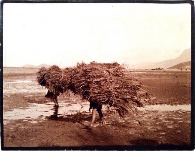
Scene at Tai Po - chinese women carrying twigs near Hong Kong
Primary tabs

Submitted by Susann
Date picture taken (may be approximate):
Sunday, January 1, 1905
Connections:
- Scene at Tai Po - chinese women carrying twigs near Hong Kong shows Place Island House, Tai Po [1905- ]


Comments
Re: Please rotate 90 degree anti-clockwise
Hi Dabid,
Please rotate photo 90 degree anti-clockwise. It is on its side.
Thanks & Best Regards,
T
Hi David,
Hi David,
Do you want me to scan it again? Same as with the other photograph which is on its side.
kind regards, Susann
Fixed now.
Fixed now.
Is that the railway line on the left of the photo?
Regards, David
Tai Po?
I've never heard of anywhere called Lai Po, but now that you mention the track, I think I can see Centre Island just to the above left of the women - it has that familiar turtle shape - so I think this is more likely Tai Po. Just not sure of the exact location though. That looks like the steep northern slope on Ma On Shan in the far background.
rail track
on second thoughts, isn't 1905 a bit too early for the railway? I think this is more likely the raised causeway that carried Tai Po Road across the mudflats near to Yuen Chau Tsai at the southern end of the town.
Tai Po - Yuen Chau Tsai
re: rail track
Hi Phil,
That location is a good match for the background and title.
I'd added in 1905 as a guess for the date. If it was 1907 instead, would this section of the railway embankment have been finished yet? I can see that work on the Beacon Hill Tunnel was underway in 1907 (http://gwulo.com/node/12151), but I'm not sure what order the sections were built in.
Regards, David
rail track
as far as I am aware the track was never built across the mud flats but was constructed along the coastline where (I assume) the ground was more solid. I'm fairly certain this was the road causeway. However, given that we can't see centre background (I'm assuming Yuen Chau Kok is hidden behind them) I can't say 100%. It just seems to make sense because I don't know where else the road was built up on a causeway like that.
edit:I think the railtrack may have been on a causeway at Tai Po Kau area, but then I don't think the background would fit as well, and also if you look carefull at the far right background there looks to be a couple of bridge arches which could be where the road first crosses the mud over to Yuen Chau Kok...? It's not too clear though.
name change
any chance we can get the picture name changed to Tai Po rather than Lai Po?
re: rail track
Hi Phil, I see what you mean - the other arm of the causeway after the 90-degree bend is on the right of the photo.
I was thinking it's a pity that the island is hidden behind their bundles, but looking at it zoomed in and there is Island House peeping over the top of the lady on the right. It must have been very new when this photo was taken. (Thanks to Susann for uploading a detailed copy of the photo that shows the details.)
Regards, David
PS I've updated the name.
Island House
David - I must admit I hadn't seen that - the AMO notes the house was built in 1905, but looking online I can't find a picture of it without its side tower. To me it looks as though the tower in the photo above is missing. So either the original house didn't have one (in which case I have no idea when it was added) or this photo was taken in 1905 before construction was complete.
Phil