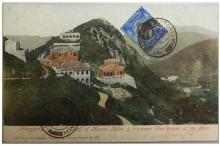
Red Hill 1 & 2, 358-359 The Peak [c.1898-????]
Primary tabs
Submitted by annelisec on Thu, 2010-01-21 18:42
Current condition:
Demolished / No longer exists
Date Place completed:
c.1898-01-01 (Year, Month, Day are approximate)


Comments
RBL 14 Marker Stone
An old RBL 14 marker stone has survived. Given its low number I guess it's quite old, but how old I wonder?
The next pic is the view looking down Severn Road from below its junction with Plantation Road. The entrance to the Kirkendoa site is on the left. Further down, on the opposite side, behind the "no entry" sign, an old, low, stone wall borders the road. The RBL 14 marker stone is embedded in the wall.
COMMENCEMENT OF LEASE TERM:17
COMMENCEMENT OF LEASE TERM:17/07/1879 - 150 years. Lease expires 2029
(The lease for RBL 14 is not on the Land Registry site, but the lot became RBL 589/590 which inherited the lease term.)
Red Hill
The earliest mention of the name "Red Hill" that I can find dates from 1898 (Peak Directory, Jury List). The name of the building previously associated with this site, "Bushy Cottage", was used up to 1890 (Peak Directory). So sometime between 1890 and 1898 "Bushy Cottage" was either renamed "Red Hill" or demolished and replaced by a new building called "Red Hill".
Red Hill
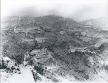
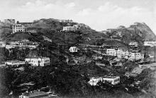
Further to the last post which was wondering if "Red Hill" was the same building as "Bushy Cottage" merely renamed, or if "Bushy Cottage" was demolished and a new building "Red Hill" constructed, the following photo dated 1897 or 98 shows no building on its site in Plantation Gap - the dip immediately to the left of the distinctive triangular peak of Mount Gough.
As we know that "Bushy Cottage" stood on its site until at least 1890, and that "Red Hill" was there from at least sometime in 1898 onwards, the absence of any building on the site in 1897/8 indicates that "Bushy Cottage" was demolished and a new building, "Red Hill", completed in 1898.
Thanks for digging in to this
Thanks for digging in to this. I'll change the completion date from 1875 to c.1898.