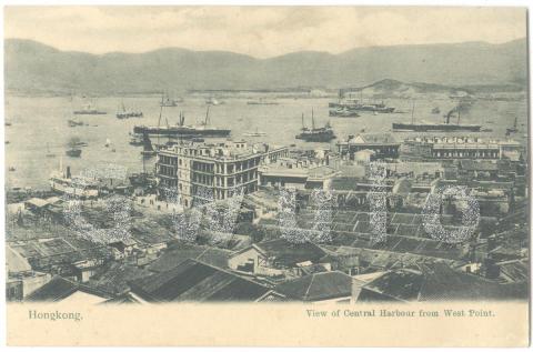
"View of Central Harbour from West Point"
Primary tabs
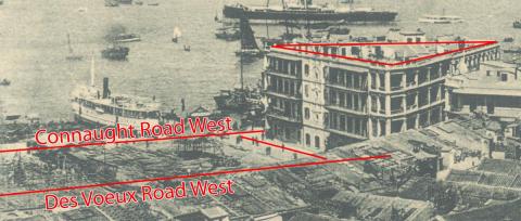
Where: The clue to this photo's location is the new-looking four-storey building in the centre, and in particular its shape: there aren't many triangle-shaped buildings along Hong Kong island's north shore.
There is one at the start of Des Voeux Road West though, and that's where I think this scene was taken.
According to the postcard's title, we're near to "West Point". Old maps of Hong Kong island's north shore used to have three Points marked: East, West, and North. North Point is still a recognised district, but East Point (near today's Excelsior Hotel) and West Point (off Western Street) have fallen out of use.
Western Street and West Point are around 500 metres west of this scene, so it's a stretch to say that's the location. Old postcard titles always need to be treated with a healthy dose of scepticism!
What: The street I've marked running between Des Voeux and Connaught Roads is Queen Street, and at the end of the street is a pier.
The pier is shown on a couple of the maps in the book "Mapping Hong Kong":
- Plate 3-5a dated 1930-45 shows it as "Chun On Wharf", and
- Plate 3-5b dated 1936-46 shows it as "Williamso???? Co. P. P. No. 6". The company name isn't clear, but I think the last part means "Public Pier number 6".
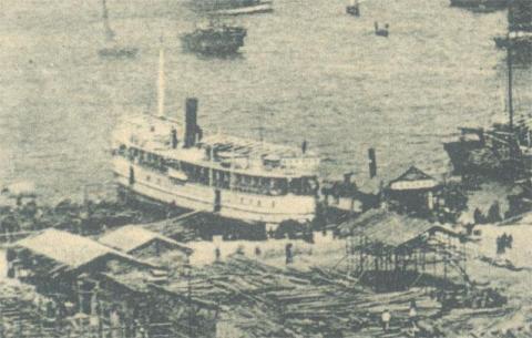
The ship at the pier looks like a passenger ship. However I don't know if it belonged to either of the companies listed above, or if another company was using that pier when this photo was taken.
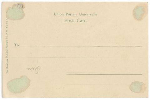
Who: The other company name of interest is the postcard publisher, shown on the back of the card.
So this is one from The Hongkong Pictorial Postcard Co. A Google search on that name shows their postcards aren't exceptionally rare, but they don't appear to have been one of Hong Kong's major postcard publishers. Can any reader tell us more about them, such as who owned the company and when it was in business?
When: The photo was taken after the reclamation from Des Voeux Road out to Connaught Road was completed, but before all the new land was built upon. That suggests a date around 1900.
The back of the postcard supports that - see how it only has space to write an address? That was the rule when postcards were first introduced: any message had to be written on the front of the card. It changed in 1907, when the Universal Postal Union allowed member countries to divide the back of postcards into two: half for the address, and half for a message. So we're likely looking at a card printed in 1907 or earlier.
Other facts that could help identify the photo's date include:
- What year was the pier built?
- What year was the triangular building built, and when were those empty plots built on?
- When did The Hongkong Pictorial Postcard Co. go out of business?
And of course any dated photos of this area from roughly 1890-1910 would also help.
If you can help narrow down the date this photo was taken, please let us know in the comments below.
Gwulo reference: K189
Further reading:
Postcard publishers in Hong Kong

Comments
Triangular Building
Don't know anything about this building, but the land where it's built on is split into many pieces (lots). See here:
Re: Triangular lot
Hi Klaus,
Yes. A few of thse opposite junction of Bonham Strand West survivled till the late 1970's or early 1980's before being torned down for redevelopment.
T
piers and ships
One 1901 detailed map (on the HK Historic maps website) shows no pier, only something like a landing place. It also shows the whole site was then divided into about a dozen lots. Another 1901 street map (same site - but presumably later in that year) shows that the lots have reduced to two addresses, 87 on the eastern corner and 87a, the rest of the site. This map also shows a pier pretty much opposite the eastern part of the buildings - i.e. 87a, i.e. almost as soon as the reclamation was finished. But this is NOT the pier with the river ferry (on which more shortly) in the photo.
The 1913 government map (same site) shows a renumbering (87 and 87a have become 37 and 37a (could be a typo I suppose)) and additional piers have popped up either side of the first pier - one immediately opposite the entrance to Queen St (the one in the photo I think), the other right where Des Voeux Rd swings SW away from Connaught Rd.
The photo shows the first of these two piers nearest the camera and the tip of the first pier with a cargo lighter junk alongside a bit to the right. The eastern pier is out of shot behind the big building on the 87/37, 87a/37a lot.
So that perhaps agrees with your 'after 1907' dating, leaving the undecided issue the year in which the various piers were built.
The auction notice for the site of the pier at the end of Queen St appeared in 1901, as were those for the end of Wing Lok St (one of the two to the east of the pier with the river steamer) and at the end of Sutherland St (to the left out of shot - http://sunzi.lib.hku.hk/hkgro/view/g1901/463511.pdf).
They do not appear to have been completed by Feb 1902, when regulations on the use of wharves don't mention them, save referring to 'landing steps' at the end of Wing Lok St (http://sunzi.lib.hku.hk/hkgro/view/g1902/466279.pdf). Indeed the sites are up for auction again in Sept 1902, so clearly they weren't in place by then despite the 1901 suggesting the opposite! (http://sunzi.lib.hku.hk/hkgro/view/g1902/468301.pdf).
It is possible that the hold up was because there were legal issues in dispute, an October 1902 notice having appeared saying that owners of piers removed by the Praya Reclamation should apply to get permission to reinstate them (http://sunzi.lib.hku.hk/hkgro/view/g1902/468301.pdf).
I haven't found anything more definitive except that in 1914 (in the report of the Director of Public Works - http://sunzi.lib.hku.hk/hkgro/view/a1914/235.pdf) Permanent Pier No. 6 (so not Public) had permission for an extension, so that gives a 'not after' date, since the pier in shot is quite short. I haven't found any other auction notices. All I have so far are for Permanent Pier No. 6 (1901 and 1902), for Wing Lok St (unnumbered, 1901), for No. 3 (aka Pasig Pier - off the end of Sutherland St) in 1901, 1902 and 1906, and No. 5 (off the end of Hillier St.) in 1905. That said, the Reports of the Director of Public Works through until c.1912 are full of mentions of a dozen or so pier leases being granted without specifiying where on the HK island shore they were.
In 1932 S(tuart) T(aylor) Williamson (later Williamson & Co.) took over the Douglas Steamship Co. (though without a name change), although there are suggestions that there was a controlling interest as of the mid-1920s, which would perhaps explain where that wharf name came from. That said, Douglas Wharf was a lot closer to Central (near the end of Douglas St.) so this will have been in Williamson's own name, since he had his own ships by before 1929.
Best,
StephenD
Photo Date
I would say the date for this picture is late 1903 - early 1904. The triangular block of houses was built on the reclamation carried out in the 1890’s This section, named Section 3 West, was completed in October 1898. From the 1898 public works report
81. Section No. 3:- This important section, extending from Wilmer Street to Wing Lok Street was finally completed under Contract No. 23 by Mr. TSANG KENG in October. The work done in the year consisted in the completion of the seawall, surfacing the roadways and footpaths, laying drainpipes and fixing gullies. The whole area is now available for building.
Nam Pak Hong Pier was opposite the lower end of Wing Lok Street.- A serious incidence of subsidence on the 3rd July 1897 necessitated the reconstruction of the sea wall around this area delaying the rebuilding of the pier.
Assuming the tenement houses would take a year or so to construct and construction could not begin until the reclamation was completed it is not possible that the picture was taken before 1900.
The 1901 city plan gives another clue as to the date:
While the lots for the houses on the new reclamation are drawn, only the ones on the triangular section have been numbered, indicating they have been constructed. In the original picture the open area to the west of the triangular section is the reclaimed land that has not yet been built on. It is difficult to be sure but it does look like there is construction activity happening (scaffolding) for a block of tenement houses just to the left of the G in the Gwulo watermark.
The triangular block of tenements is actually two separate buildings. The base of the triangle abutting Queens Street is one section while the point is another. This can be seen in the lot map. The way the reclamation was carried out was that the holders of the existing Marine Lots would be entitled to the reclaimed land but would assume the costs of the reclamation. The owner of ML37, at the end at the end of Wing Lok street had a large area of existing marine frontage so was allocated a large part of the reclaimed land.
It is likely the Lot numbered 87a (a typo – should be 37a) was sold by the owner of ML 37 to recoup the cost of the reclamation.
The picture was taken from Hospital Road just below the Berlin Mission house. The roof of the Ko Shing Theatre can be seen at the bottom of the picture below the W in the Gwulo watermark. Here is a picture taken at roughly the same time looking back at the Civil Hospital.
The triangular block of buildings would have been behind the photographer. The majority of the buildings on the block survived until c1990 when it was redeveloped. However the very eastern tip, now 1 Des Voeux west was redeveloped earlier. (in the mid to late 1970s)
The below Public Work reports shows the progression of Pier construction in the area.
1899 Public Works Report
Seven temporary wharves were built out from the new sea wall, on Sections 3, 4 and 5, by Launch and Steamboat Owners principally to take the place of wharves abolished by the reclamation Works. The Tai On Steam-ship Company are new erecting a permanent timber wharf at the foot of Cleverly Street, and the Hongkong, Canton and Macao Steamboat Company are building an iron pier opposite Marine Lot No. 22.
1900 Public work Report
39. Praya Reclamation:- The report of Mr. J. R. Mudie Executive Engineer in charge of the Praya Reclamation Works, is quoted in full below:
Owing to scarcity of labour, and the starting of the Naval Yard extension works, and the reclamation and Dock works at Quarry Bay, the progress on the Praya reclamation during the year has not been very satisfactory. However, good and useful work has been done, sections 4 and 5 from Wing Wo Street to the end of Wing Lok Street where the Nam Pak Hong Pier stood, have come into full use although the roadways are unsurfaced. Building operations on the reclaimed land are in active progress and the draining and sewering of the land has been completed, as well as the laying of gas mains, erection of street lamps, &c., &c. The new Canton steamer wharf was completed and opened for use in November, just in time to take the place of the temporary pier at the end of Wing Lok Street which was almost completely destroyed by the typhoon on the 10th November.
1902 Public Works
Piers: - ln consequence of the numerous applications received for the right of erecting piers opposite the ends of public streets, in certain portions of the City, recourse was had to public auction for the disposal of such rights, with the result that a substantial sum ($53,520) was realized. With the exception of $1,020 paid for a pier on a short lease at Yaumati, the above amount was derived from 3 piers opposite the West end of Wing Lok Street, Queen Street and Sutherland Street, respectively, for all of which leases extending to the 31st December, 1949 will be issued. Rent is payable under the Piers Ordinance (No. 37 of 1895).
Licences were issued for 10 temporary piers in Hongkong, (1 in Kowloon and 6 in the New Territory, the amount of fees payable for these being $1,659.48.
So it seems likely the Pier at the end of Queens Street was in place by the end of 1903 at the latest. A picture from the 1950s showing the pier at the end of Queen Street:
The ownership of the pier seems to have changed hands a number of times. A map from the 1910s show it to be the pier for the Canton Navigation Co Ltd French Line. I could not find much about this company except the following:
The organisation of the "Messageries Cantonaises" shows that the French are far from being disinterested spectators of the commercial life and development of the Chinese provinces around their beautiful Colony of Tonkin, The Company which was floated in 1907 by the Compagnie Française des Indes et de l'Extreme-Orient is subsidised by the Government of Indo-China, and retains the French postal service between Hongkong, Canton, and Wuchow (Kwangsi). Under supervision from the Paris headquarters it operates the steamships Paul Beau and Charles Hardouin, both of which are speedy and comfortable. The Paul Beau is named after the Governor-General of Indo-China, and the Charles Hardouin after the late Consul-General for France at Canton, who actively occupied himself in the foundation of the line. The two steamers are of 1,900 tons each. They were built at Nantes in 1904. and have a speed of 14 knots. The registered office of the "Messageries Cantonaises" is at Canton, and the agents in Hong Kong are the well known firm of Messrs Barretto & Co. Te local director of the Company is Captain P.A Lapicque, of the French Naval Reserve.
Source: 20th Century Impressions of Hong Kong Shanghai etc (1908) p207.
The end of the Canton Navigation Co Ltd French Line?
The Chinese river steamers "Charles Hardouin" and "Paul Beau," each 1,671 tons gross, 909 tons net, built and engined by the Cie. Francaise de Nav., Nantes, in 1903 and both owned by the Canton Navigation Co., Canton, have been sold at Hongkong for $1,045,000 net, the purchasers paying an additional $260,000 for converting the boats into ocean steamers.
Source: The Seamen's Journal, Volume 32 No 2 September 18, 1918
More on the company here including more pictures of the steamers
It is possible that the boat picture in the original photo was either the Charles Hardouin or the Paul Beau. Here is a picture of them berthed at what seems to be the Wing Lok Street Pier in HK:
The original picture resolution is not good enough to be 100% sure. The Charles Hardouins history:
Charles-Hardouin - River transport of 1,665 tb; 67.70 x 11.60 x 3.76 m; two triple expansion machines; 1,100 hp, 13 knots. Launched under this name in 1903 by the French Shipbuilding Company of Nantes, on behalf of the Compagnie Nationale des Messageries Cantonese (J. Trévoux & Cie) , Canton (China) . Armed at Nantes on November 12, 1903 and arrived at Hong Kong on January 14, 1904; made his first trip on the Canton river on March 18, 1904.
Sunk on April 6, 1945 between Canton and Macao by a mine dropped on March 4 by a US Air Force plane .
If they are the same steamers they likely both would have arrived in Hong Kong by the end of 1903. (I cannot find any information on the arrival of the Paul Beau in HK) The rest of the praya was rapidly developed with tenements so the picture cannot have been taken much past 1904.
dating
Terrific material Herostratus. I should have twigged the Charles Hardouin or Paul Beau...have full details including a menu for Christmas Day 1912 which, for a French vessel, was stunningly Anglais: Star Vermicelli soup, fired fish, fried snipe on toast, stewed rabbit, boiled cauliflower, roast capon and ham, plum pudding, cheese, fruits, coffee/tea.
The ships were in French ownership (wonderfully named Compagnie francaies de Navigation et de Constructions navales et Ancien Etablissement de Satre Reunis!) and under French operation (Messageries cantonnaises/J. Trevoux & Co.) from 1903-1904 when Trevoux went bust. By Feb 1905 they were back in business operated by Captain P.A. Lapique's Compagnie francaise des Indes et de l'Extreme Orient, although newspapewr adverts suggest the original operator name had been retained and at which time they boasted the finest French cuisine and wines. There was deadly rivalry between the French service and the British service operated by the Hongkong, Canton, Macao & West River Steamers that resulted in an unofficial 'race' in 1910, which the Brits won in the courts because they lost on the water.
In 1913 negotiations began for the two ships to be 'taken over' by the ostensibly Chinese owned, Guangzhou based, Canton Navigation Co., althugh both French skippers stayed in command, and Mr Kwok Ying-ting, the local manager, would continue to manage the ships for the new owners. In June the change of flag to the new Republic of China was complete. The Canton Navigation Co operated the ships until 1917 before they were sold to the San Peh SN Co of Shanghai and renamed Wei-Shun (CH) and Ming-Shun (PB), who ran them in Shanghai waters until 1923 when they were bought by a Chinese sydicate.
The new owners relaunched the Canton Navigation Co. with the two ships reverting to their old names but flagged in HK. In 1927 the Canton Navigation Co (aka Kwangtung Navigation Co), badly affected by the paralyzing of the river steamers by the general strike, was in trouble and in November 1927 the ships were chartered by the Tung On Steam Ship Co Ltd (I think of HK) until June 1928 when both were laid up and were registered as owned by the solicitors handling the winding up, Woo & Mok Ltd.
They were taken in hand again in October 1928 and in January 1929 went back into service on the Kongmoon run, managed by The San Nam Steam Ship Co, said in some sources to have been the charterers (Manager Chow Jar-hoo, main owner Chau Kam Wing of HK). All seems to have gone swimmingly, though with the one major contretemps between the manager (as a passenger) and the gweilo Chief Officer, which the gweilo won in court but lost his job (!), until August 1930 when both ships were up for auction.
Mr Ko Ho-wing owner of the Tung On Steam Ship Co. bought both vessels for $205,000 and a bunch of wharves in Guangzhou as well. In the autumn they were docked at Taikoo to be readied for service and resumed service in January 1931 under the Portuguese ensign. By 1932 there were crew problems and in general problems because of the increasing impact of Japan's activities in China. Towards the end of the year the Paul Beau was taken out of service and the Charles Hardouin was threatened with the same fate because Tung On was also operating two newer ships and business was tight.
In March 1937 the pair were up for sale for $300,000 (Tung On claimed their total cost since purchase, including mortgage interest payments, was over $1,000,000) on the condition that they were not operated in the Pearl River area for ten years after purchase (!). That seems not to have happened, because the ships were bought in late 1937/early 1938 by the Tai Sang SS Co, their names changed to Kau Tung (CH) and Macao (PB).
In April 1938 both began service on the Macau run. Both ships were still in service on the Macau run in July 1941 when the requirement for enlistable males to have exit permits to leave HK resulted in a notice in the newspapers saying that tickets could only be purchased to go to Macau on presentation of an exit permit. In August that year, when restrictions to access to coal supplies were announced, the Kau Sang & Macau were noted as belonging to or being managed and operated by the Sing Wo SS Co.
We know the fate of the Charles Hardouin, which was as Herstratus notes. The Paul Beau's fate is less clear, though I have a trace memory that she was scuttled in Aberdeen or somewhere in HK waters during the Battle of Hong Kong.
Stephen D
Triangular building
Coming back to the triangular building. The ~1900 bulding seems to be a single building whereas on Herostratus' aerial photo from 1950 it looks more like a densly packed group of houses. This would reflect more the high high number of lots.
I found a photo from 1980 showing the place.
Des Voeux Road West - 3 (Hong Kong), 1980, by Leroy W. Demery, Jr.
If we assume that the tram is heading east, Queen Street is left in the bend of the road, and Bonham Strand West is front left (with the Do Not Enter sign). The triangular building should then be on the right. This fits better with 1950 photo as it looks more like a series of houses than a single building.
Its definitely the same
Its definitely the same buildings, on the c1900 photo 2 towers are atop the building on the middle of the Queen Street side, for what I assume are the tops of staircases. These can be seen on the 1950 aerial photo as well. It is also possible to see that 2 different styles were used in construction, the building at the point of Des Voeux Road West and Connaught Road has a different window arrangement to the Queens Street part.
Here are some more pictures of the building:
It does seem there was some redevelopment of the buildings before the whole site was cleared c1990. No 17, the corner unit, has been replaced with what looks like a 1960s walk up in the 1989 photo, however the majority of the block did survive intact until redevelopment.
TI think the reason the buildings look so different in the 70s/80s is the typical Hong Kong standard of illegal extensions/balcony enclosures etc.
Another picture from the
Another picture from the 1980s showing how the tip of the triangle at the Junction of Connaught and Des Voeux Road West was demolished prior to the rest of the building:
Dating the "Paul Beau"
The "Paul Beau" arrived in Hong Kong harbour on 21 December 1903. Informaton on its arrival can be viewed in the China Mail dated 19 and 21 December 1903.
The vessel had a trial run in the harbour on 3 February 1904 before leaving on its maiden voyage the following night. The vessel arrived in Canton in the early hours on 5 February. China Mail 6 February 1904 refers.
There are notices in the China Mail of the maiden voyage of the “Paul Beau” departing from the pier at the end of Queen Street, Praya West.
Thanks for the thorough
Thanks for the thorough research into this scene.
One little snippet for future use is that the new marine lots were given the initials P.R.M.L. to distinguish them from the original lots. The P.R. stood for "Praya Reclamation."