Prohibited anchorage area - telegraphic cable reserve [1907-1924]
Primary tabs
The area is shown on map 1923 at http://www.hkmaps.hk/mapviewer.html. Does anyone know why ships weren't allowed to anchor here? [Update: because there were telegraph cables on the seabed here, that could be damaged by ships' anchors - see comments below for details.]
There's a description of its boundaries on p.504 of the 1925 book, Asiatic Pilot: The western shores of the China Sea from Singapore Strait to and including Hong Kong:
Prohibited anchorages—Lights.—The prohibited anchorage between the northern point of Hongkong Island and the southeastern point of Kowloon Peninsula is marked as follows:
Two white beacons on the shores of Kowloon and Hongkong Island, and two white masonry obelisks, situated northwestward and southeastward of them, respectively; when the beacons are in range with the obelisks, bearing 333° and 153°, respectively, they indicate the boundaries of the prohibited anchorage lines 300 yards apart.
By day the four beacons forming the front marks may be distinguished by their each carrying a red diamond shape; by night each displays a red light.
The lights are so screened that the easternmost lights do not show to the eastward nor the westernmost lights to the westward of the prohibited area; when, therefore, the two lights on the same side are visible at the same time, vessels must proceed until one or other of the lights is obscured before anchoring.
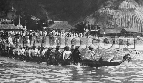
The southeast obelisk is shown in the top left corner of this photo, and the diamond for its beacon is above the right-hand 'o' of the watermark.


Comments
Re: Prohibited Anchorage
Anchorage was prohibited as the area was a telegraphic cable reserve. See here
Re: Prohibited Anchorage
Thanks Moddsey, that's good to know. Now I know that, I can see the telegraph cable shown in that area on Map 1936 at http://www.hkmaps.hk/mapviewer.html
First notice
A prohibited anchorage (and another off Stonecutters) was gazetted in Govt Notification No. 201, 7th May 1892, initially marked by "white posts" exhibiting red lights at night. The fine for anchoring therein was $50 and the cost of repairing any damage.
As we shall see however (marine charts and Notices to Mariners are more useful for sorting out issues related to the harbour than seems often to be realized), there's a lot more to the story.
The enforcement of protection against anchors wrecking submarine cables followed the 1885 Submarine Telegraph Act passed in UK 6th August 1885, which applied in HK by extension and therefore required local regulations to give it effect. The UK Act followed Britain's adhering to the International Convention for the Protection of Submarine Telegraph Cables of 14th March 1884. The application of the UK act was gazetted in HK on 7th November 1885.
The first notification of marking seems to have come on 24th Feb 1886, when a government announcement warned junks (!) not to anchor in the area between Hung Hom and North Point marked "by posts carrying large diamond shapes" (still an international sign), two on each side marking a zone within which the cable had been laid. The warning was repeated roughly yearly until that May 1892 new Order in Council was passed (Govt Notification 298, Gazette 19.6.1897) under the Merchant Shipping Consolidation Ordinance 1891 announcing the same prohibited zone as in 1886. This was repeated in 1897.
Interestingly the harbour chart of 1888 (BA1459) of that year does not show the cables, though the Stanford Map of Hong Kong with British Kowloon does and, to boot, does so in a way that shows the prohibited zone not to cover all the cables, since although both the HK Government cable and the Canton Telegraph Cable leave Hung Hom at pretty much the same point, the former lands at Whitfield (near where the old Oil St RHKYC premises are today) and the latter on the tip of North Point. A cable and its markers and lights is shown on the 1901 edition of BA1459 and the 1903 update - though only the HK Government cable line.
But it seems that between this first exercise and the one in David's photo, we find that the whole prohibited anchorage zone has moved. The cables being protected in 1923 are new ones a few hundred metres further east and, rather than there being one obelisk above North Point, the prohibited zone was marked by two.
The happy additional murk is cast when we get to the July 1923 edition of BA1466 (the original Belcher chart, by this time in its 13th edition) which shows the TWO obelisks, about 125m apart, covering a swathe of water from North Point eastwards, so not at all on the line of the 1880s government cable and its cable house shown on the 1888 BA1459 and the Stanford map. Evidently between the original markers with the white posts and 1923 and the obelisks new cables had been laid and the old landing place had been got rid of with the development of the Dutch Oil Depot where Oil St now is.
So the hunt switches to when the changes occurred, which will give the terminus a quo for the erection of the obelisks. The War Office 1909 map gives a hint by showing only one cable running along the 'new line' (i.e. the more easterly one) and a major change to the shoreline further west where the old cable had landed, suggesting that shoreline changes between 1903 and 1909 caused the move.
The answer is given in Government Notice 771 of 11th November 1907, which announced the movement 400 yards eastwards of the cable zone and its marking by white posts and white obelisks on both shores marking the extent of the zone, with screened red lights at night shining over discrete arcs. The move had begun with the shifting of the eastern limit of the Cable Reserve in June 1907 (notice 386, 6th June 1907) - I can;t trace Notice 1053 of 1906, but the intention to make the move would appear to have first appeared at that time.
But this whole cable reserve in the Harbour proved temporary. Notice 484 of 20th August 1924 indicated that a new cable reserve was planned for the central area of Victoria Harbour. This was announced as having been laid during September 1924. Maps from roughly this period also seem to imply strongly that because of all the reclamation going on at North Point, the cables running from Hung Hom to there had been either lifted or left to their fates. This is confirmed by BA3279 (Hong Kong Waters East) which shows no cables at all off North Point, no obelisks and no prohibited anchorage.
Best, StephenD
Thanks Stephen, lots of good
Thanks Stephen, lots of good information there. I've updated the page to note this prohibited anchorage was in existence from 1907-1924.
Up at the top I quoted a description of this prohibited anchorage in the 1925 copy of Asiatic Pilot. I guess the change happened after that year's issue had been compiled, and that if we could see a 1926 copy we'd find this prohibited anchorage had been removed.
Now we know the dates I'll keep an eye out for photos of Hung Hom or North Point in those years that show any of the other three obelisks.
Prohibited anchorage
Pilots/Sailing Directions (all same thing) weren't updated annually. Amendments were made to an edition via Notices to Mariners (one was expected to keep one's copy up to date) until everything had become so unwieldy that a new edition was published. The 1925 ed was the 2nd (the first had been in 1910) and the next ed of the US Hydrographic Office Asiatic Pilot didn't come out until 1929 - no online copy of Vol. IV (with HK) seems to be available.
The relevant British Admiralty volume, the China Sea Pilot, had its editions of vol. IV in 1912 and vol. II in 1936 (when there had been a wholesale revision of coverage reducing the China Sea Pilot from six volumes to three by hiving off the Malacca Strait, Japan and Korea, etc.).
It follows that the definitive source for pinning down dates is always Notices to Mariners. Where changes within a formally administered port were concerned, these were initially issued by the local port authority (in pre-WW2 days, the Harbour Master), so in HK published in the local, HK Govt Gazette. The info was forwarded to London and usually (not always) published rather later in the London Gazette as well as, by the 1920s, also distributed to Admiralty chart agents so charts and publications could be updated before sale usually in the form of the weekly or monthly NTMs - a fat jobbie that included all new information about anywhere in the charted world. Sometimes NTMs were also published in local newspapers, though that seems always to have been a bit hit-and-miss.
The 1907-ish date for the obelisks is interesting because of the erection of the compass-swinging obelisks in Tai Tam, which is reported as an 'encroachment' on public land in para 19 of the 1910 Report of the Director of Public Works. The implication of the report is that the obelisks may have been around for a while before the Government woke up. From the look of your photo it seems they're all pretty similar.
As a result of that hint I've now solved an old, old problem. It turns out the Tai Tam obelisks were erected at some time in 1900 (London Gazette, , Issue: 27246, Page: 6936) and, contrary to the idea of compass-swinging, I now learn were positioned for exactly the purpose I had initially supposed, to offer a leading line into Tai Tam Bay clear of Castle Rock and Beaufort Island. No further explanation is given, but given that Tai Tam was used for fleet anchorages when the China Station ships went off exercising, perhaps having a leading line was thought wise.
Interesting that it took PWD ten years to wake up to the naval encroachment on government land. Not that it made any difference, since the navy got away with it. Perhaps more interesting is that the measured course (that was still around when I first started sailing in south of the island waters in 1974) that ran from Bluff Head (Wong Ma Kok) up the East Lamma Channel to end at Round Island (then called Ma Kong), that also featured in the Director of Public Works' 1910 complaint about naval encroachments, had been in place since before 1893 according to an NTM of that year (The London Gazette, 8th August 1893, p. 4528)!
StephenD