Hung Hom Police Station (1st generation) [c.1875-c.1950]
Primary tabs
Submitted by Klaus on Wed, 2020-02-12 23:59
Current condition:
Demolished / No longer exists
Date Place completed:
c.1875-01-01 (Year, Month, Day are approximate)
Date Place demolished:
c.1950-01-01 (Year, Month, Day are approximate)
Hung Hom Police Station near todays Station Lane (sic). Opened in the mid-1870's. Can easily be seen on the 1896 map.
Update 2022-01-06 (see comments below)
Demolished in the early 1950's when this area was developed for housing estates. A new police station opened in 1950.
Source: The Hong Kong Police; Police History: Chapter 1 History – The First Century
Tags:


Comments
THE HONGKONG GOVERNMENT GAZETTE, 7th SEPTEMBER, 1872
GOVERNMENT NOTIFICATION.
Tenders will he received at this Office, till Noon of Monday the 16th instant, for the erection of a Police Guard House at Hung Ham(!), Kowloon.
The Plan and Specification can be seen, and further information obtained, on application at the Surveyor General's Office.
A Proper form of Tender must be applied for at this Office. The Government does not bind itself to accept the lowest or any Tender.
By Command, CECIL C. SMITH, Acting Colonial Secretary.
Colonial Secretary's Office, Hongkong, 7th September, 1872.
source
Date of domolition was much earlier than 1989
Government started to remove the Kun Yam hill at that site of Ka Wai Chuen as early as 1954. The Hunghom chuen was built there from 1955 to 1958. It was demolished around 1990s to make way for Ka Wai chuen. The police station moved to the Chatham-Hok Yuen junction earlier in 1950.
=============================================================
Red dot is the location of the old police station near station lane on a 1950 map not long before moving:
=============================================================
A 1949 aereal view of hunghom shows that corner at the intersection of Ma Tau Wai rd and station lane.
A lot of squatter huts up Kun Yam hill. One can see some small buildings downhill at that corner. But it is not clear which one is the police station.
=================================================================
Kun Yam hill at Ma Tau Wai-station lane junction demolished 1954. Hunghom Chuen built here in 1955-1958.
It is even possible one of the small houses around the corner on the left side of Ma Tau Wai rd was the "police guard house" in your description.
More information about hunghom chuen can be found here:
https://www.hkhs.com/tc/housing_archive/id/14/scheme/4
========================================================================
Air view in 1968 clearly shows Hunghom Chuen at that site:
========================================================================
News report on 1949-8-1 that a new police station and police staff quarters to be built at Chatham-Hok Yuen junction. It said it would take 9 months. That means it was opened around May 1950.
==========================================================================
1964 picture of the new fat kwong flyover over chatham road north. First building behind it on the right was the police station built in 1949
=============================================================================
red circle indicates location of new police station which was opened in 1950 on a 1967 map:
==========================================================================
police station
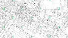
In a 1935 map it seems the station was not at the street level. One needs to go up some steps to a ridge of Kun Yam hill.
As indicated from the 1920
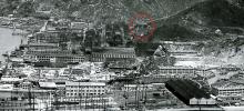
As indicated from the 1920 and 1935 maps, the police station was situated on a ridge of Kun Yam Hill and above Taku Street. I think that the police station (inside the red circle) can be seen on this 1920s photo of Whampoa Dockyards.
police station
Also like to take a wild guess about this 1956 photo of the squatter huts on Kun Yam hill near ma tau wai rd. The white building on the right had a rectangular shape. So was the one on the left. They were perpendicular to one another. With the latter one being higher up the hill. It is consistent with the 1935 map regarding their shapes and orientations. They don't look like squatter huts. So it may be reasonable to assume the one on the left is the police station.
=======================================
Re: Police station
Hi simtang, this is a very interesting photo. If this is from the mid-1950s, it probably does not show the police building from 1875.
Two aerial photos from 1945 and 1949 show the area where the police building should be. On the 1945 photo two buildings can be seen (or actually guessed) in the right circle - this matches the location and the shape of the houses as seen on the 1935 map. On the 1949 photo, it looks as if the buildings were demolished between 1945 and 1949. Instead, cubical-shaped objects are at this place - these surely are the squatter huts that can be seen on your photo. So a clear photo of the police station is probably still to be found.
We don't know when the police
We don't know when the police station was demolished. The Hunghom chuen was built in stages from 1955 to 1958. The 1956-9 picture shows clearly the Kun Yam hill was not completely removed with still a lot of squatter huts and buildings left.