Hut for caretaker [????- ]
Primary tabs
Submitted by Admin on Sat, 2012-09-29 13:06
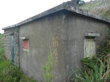
This is the first hut you see on the path up from Nam Shan.
Tags:
Photos that show this place
 2012 |
This is the first hut you see on the path up from Nam Shan.
|
2012 |
Download free sample chapters, or buy the books:

Click on your area of interest to choose from over 30,000 pages about old Hong Kong:
Or choose a popular article:
A timeline of Places at this site.
This:

Comments
Caretaker's hut
Thanks to Don Ady for his help identifying this one:
[That's] almost surely the caretaker shack. The caretaker shack was on the trail maybe 50 to 100 yards before one hit the camp saddle trail. If that is the shack, I don't remember fine details, it might have been enlarged just a little.
Caretaker's hut
Was the caretaker's hut also the Mess hut?
Mess & Caretaker's hut
Hi,
The Mess is this one: http://gwulo.com/node/13364
I think Don is right that the caretaker's hut has been extended. The photo shows the left half is built from stone like the other huts in the area, but the right half looks like it was built from concrete and added later.
Regards, David
Caretaker's Hut
No. If you continue past it toward the camp, Westward, you get to the main camp trail. First building next on the right, going right and westward toward Sunset Peak, is the Mess. On the North side of the mess is a "patio" of sorts which is really a roof of a structure built into the downslope. I never went in it, but believe it to be quarters for the cook and extra storage space for provisions. Also there may have been extra bunks for porters should they need to stay over night - seldom if ever used. The caretaker before WWII was named Lum Fook, but he was not there postwar.
Re: the Mess
Hi there,
Ah, that roof..... in the past few years everytime I went pass the camp I would usually take my break right on that particular location, overlooking the Airport. On a clear night that place would also be good for star gazing too. Better than lying on the gress or at the trigonometrical station at the Peak further up. The Peak does have a better view on all directions, however.
Best Regards,
T
Re The Mess
I think one of these days, I'm going to find my hiking boots and get up there.
Its too confusing looking at photos and Google Maps.
cheers
Re: Try Bing Maps
Hi Firestar,
You might like to try Bing Maps on this. I don't like Microsucks, but for this topic their Bing Maps has a clear layout of the huts. Just search for sunset peak, lantau using Bing Maps will do, then zoom right in.
Best Regards,
T