Army Sports Ground, Mongkok [????- ]
Primary tabs
Submitted by barbaramerchant on Thu, 2013-10-10 16:14
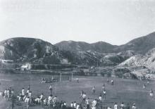
I found these three photos in a packet with others taken by my grandfather Tom Hutchinson dating from 1937, which may show the old Army Sports Ground in Mongkok. The sports ground was taken over by the Urban Council in 1961, and is now the site of the Mongkok Football Stadium.
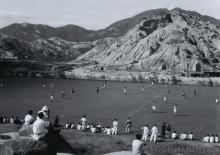
The photos seem to be taken facing North, and the 3rd photo I think shows the railway bridge going over Boundary Street, with houses in Kowloon Tong beyond.
Can anyone confirm this?
 1937 - photo by Tom Hutchinson")
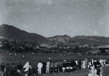
 1937 - photo by Tom Hutchinson")
 1937 - photo by Tom Hutchinson")
Barbara
Tags:
Photos that show this place
 1937 |
 1937 |
 1937 |


Comments
That sounds right. I've
That sounds right. I've changed it to a Place so we can see the location on a map.
Regards, David
Hillside on South of Mongkok sports ground/stadium
Thanks David. I was unsure if this was the site of the present Mongkok Football Stadium as on image 2 the spectators seem to be on a hillside on the southern edge of the sports ground, and there is no hill there now. However, yesterday I realised that part of the hill is still there, at the Bird Market end of the stadium. It is visible from Flower Market Road, and from the top of the Bird Market.
It might even be that this hillside is the northern end of the substantial hill that was cut through to build Prince Edward Road, upon which Queen Elizabeth School etc was eventually built, and which shows as a sheer cliff on http://gwulo.com/node/17423.
Barbara
Tai Hang Tung Estate
This photo complements Image 2. I think the photos show the sports fields north of Boundary Street.
1955 Tai Hung Tung Estate
North / South?
I think the sports ground in Barbara's photos show the sports fields to the south of Boundary Street, based on the third photo:
There's a railway bridge at the far right of the photo, which looks like the one across Boundary Street. With the hills in the background, that will put the fields and the photographer to the south of the street.
Mapping Hong Kong has a good sequence of maps of Kowloon. There was a small hill that was about where the slope in the second photo is shown. Its southern half was cut away when they built Prince Edward Road.
Regards, David
Re: North/South ?
The field south of Boundary Street had a nullah that dissected the playing area as show in the map below:
1930 Boundary Street between Nathan Road and Embankment Road
Re: North/South
Hi Moddsey - I think that nullah is still there, and covered over, forming a walkway which skirts the North-West corner of the current Mongkok Stadium. If this sports ground was in the exact same spot, the nullah would have skirted it somewhere to the left of photo 1, I reckon.
Barbara
Wish I had those maps....
Re Nullah
Re Nullah
Can't seem to find that Flickr photo for the moment, however your map certainly shows the nullah continuing across Prince Edward Road to become the nullah on Nullah Road. The walkway I mentioned above is named Flower Market Path, and if you continue in a straight line from where it emerges onto Flower Market Road, it traces the cut-off corner of a building on Prince Edward Road and Sai Yee Street, crosses Pr Ed Rd and joins up with Nullah Road.
Barbara
Re: Flickr photo
The Flickr photo appears here showing the nullah across the playing fields south of Boundary Street. As the nullah does not appear in the 1938 photos that you have posted, I am of the view that the playing fields shown perhaps are north of Boundary Street and close to the Kowloon Hills
Re: Flickr photo
Many thanks Moddsey. Might I suggest that this photo is just south of the area in question. Your map above, though, is almost unchanged from what we can see now on Google maps. The old nullah, and the current Flower Market Path, look pretty much identical. Both just skirt the Mongkok Stadium, and divides it from what is now the Boundary Street Sports Centre 2.
Regards
Barbara
Re: 1938 Photos
Well, the hill with the spectators appears to be south of Boundary Street. I might be wrong but given that the playing fields shown are close to the Kowloon Hills, I am just thinking of north.
If it were south, I would imagine that Boundary Street would be visible in the photo.
Nullah?
I've added a couple of lines to the first photo:
The red line marks what could be Boundary Street, running along the north edge of the pitch until it meets the railway bridge. You can see some people walking along it in this photo, and a car on it in the second photo.
On the left of this photo there's a dark line running across the ground at an angle to the road, which I've marked in blue. Could that be the nullah? It leaves the road at the corner of the pitch, which would be about right based on the size of a football pitch shown on the current satellite view.
Then the hill beyond the street shown in the second photo could be the hill above the letters "FR" on the 1930s map.
Regards, David
Re Nullah
Hi there,
The Nullah has very much to do with the name 'Tai Hang Tung'. Tai Hang (大坑) in general (for its namesake not to mix up with the one in Causeway Bay) means a stream or a nullah. The 'Tung' (東) here means the directional East. Tai Hang Tung means East of the Tai Hang. There is in fact a village (now a few blocks of public housing) called Tai Hang Sai (Sai =西 West of the Tai Hang) on the other side of the road, next to present day Sek Kip Mei MTR Station.
It would seem the upstream of the nullah went a few city blocks north of Boundary Street, along Tai Hang Tung Road. If you take a look at the present day map, you should still be able to see traces of the covered nullah.
My 2 cents,
T
Re: Red and Blue Lines
Thanks David - that appears plausible and go with the initial findings for the location . As the name suggests, Boundary Street looks like a frontier road.
Barbara - the map is available here
The map
oh that's fantastic! many thanks! I see from the map that where Tom Hutchinson moved to in 1961 was Kowloon Inland Lot No. 2201. The family still lives there, and the Deeds make fascinating reading.
Thanks again
Barbara
The map
Here is the relevant section of the map overlaid onto Google Earth - not perfect but OK:
Barbara
Great work
Great work with the overlay. At least the hill where the spectators are fits nicely into the scene. I note the hill was accessible by bicycle.
Sports ground in 1970
This aerial photo from 1970 gives a good overview, although some 30 years later.