Date is a guess
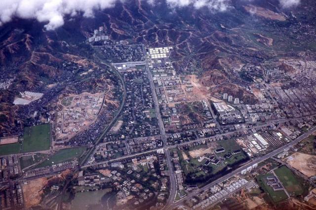
1950s Kowloon Tong Aerial View
Primary tabs

Date picture taken (may be approximate):
Wednesday, December 1, 1954
Gallery:
Connections:
- 1950s Kowloon Tong Aerial View shows Place Central British School / King George V School / KGV School [1936- ]
- 1950s Kowloon Tong Aerial View shows Place Diocesan Boys School, Kowloon [1926- ]
- 1950s Kowloon Tong Aerial View shows Place 166-188 Prince Edward Road [????- ]
- 1950s Kowloon Tong Aerial View shows Place 190-220 Prince Edward Road W Shop Houses [????- ]
- 1950s Kowloon Tong Aerial View shows Place Kowloon Hospital [1925- ]
- 1950s Kowloon Tong Aerial View shows Place St Teresa's Church [1932- ]
- 1950s Kowloon Tong Aerial View shows Place Kowloon City Police Station Argyle Street [1950- ]
- 1950s Kowloon Tong Aerial View shows Place Junction Prince Edward Rd and Boundary St [????- ]
- 1950s Kowloon Tong Aerial View shows Place La Salle College (1st generation) [1932-1978]
- 1950s Kowloon Tong Aerial View shows Place Maryknoll Convent School [1937- ]
- 1950s Kowloon Tong Aerial View shows Place Kowloon Tong Club [????- ]
- 1950s Kowloon Tong Aerial View shows Place Kowloon Tsai married quarters, Pilgrim's Way [????-????]
- 1950s Kowloon Tong Aerial View shows Place HSBC tower blocks at Nga Tsin Wai Rd [c.1950-c.1957]
- 1950s Kowloon Tong Aerial View shows Place Kowloon Sam Yuk Primary School [????- ]
- 1950s Kowloon Tong Aerial View shows Place Kowloon Tong [????- ]
- 1950s Kowloon Tong Aerial View shows Place Argyle Street Camp for Chinese Interned Soldiers / POW Camp / Barracks [1939-????]
- 1950s Kowloon Tong Aerial View shows Place Argyle Street Camp Nos. 3 & 4 [????-????]
- 1950s Kowloon Tong Aerial View shows Place Osborn Barracks / PLA Kowloon East Barracks [????- ]


Comments
Notes on photograph
IDJ:
An interesting aerial picture for anyone who has lived in or is now living on north Kowloon. KGV school is bottom right, Kowloon Tong centre, Beacon Hill as yet fairly undeveloped
OldTimer:
From Boundary St, access down to the nullah was a easy climb. This nullah could have been a major source of water which flooded the street to the west after torrential downpour.
The backlane behind the houses on Cumberland Road was quiet, unobstructed and excellent for riding a bike. From the railway track, stepping into what is now Yau Yat Chuen was like entering a rural village in New Territory.
Are those squatter houses north of Boundary St by the track? I remember that area was grassland in the early 1960s after a fire destroyed much of the sqauatter houses in the same spot about a decade prior.
Can someone enlighten me why Boundary St has a bend under the train track.
fivestar:
This looks like mid 50ss photo.
If one looks at Kadoorie Avenue/Hill, Grand Court is still under construction and also St. Georges Court. Grant Villas has not even commenced it is still grassland.
moddsey:
Added the photo for the thread. Agree that it is from the 1950s.
1950s Kowllon Tong Areial view
Grand Court was completed in 1955, so this photo must be earlier than then. Probably 1953ish judging by the construction stage.
Kowloon Tong Aerial Photo
In this post , the 3 Tower blocks at mid right being under the flight path of the reclaimed single runway at Kai Tak were subsequently knocked down. Interesting to note that the military quarters at Pilgrim's Way at Beacon Hill had already been constructed as noted here
I've added Places for the
I've added Places for the military quarters (http://gwulo.com/node/24060) and the HSBC quarters (http://gwulo.com/node/24061).
Thanks for uploading the photo, it shows lots of the buildings we've talked about in this area.
Regards, David
Sam Yuk Primary School
The low spot at the northwest end of Fa Yuen St looks like Sam Yuk Primary School. Its entrance was on Fa Yuen St. The P2 (1951) attendance was most pleasant in my education years, 16 students in a class, small but good enough playground for this adventurous boy.
Yau Yat Chuen, Fa Hui Park (future) and the Polo Ground
Yau Yat Chuen - the barren patch being built up on the west, is boardered on its east by a very tightly packed settlement. Is that a squatter area? That area will become Fa Hui Park.
Additionally, the grass pitch to the south-west of Yau Yat Chuen (present day Tai Hang Tung Recreation Ground) was known as a Polo Ground in a 1957 Kowloon Map. I wonder who played Polo in Hong Kong at the time? Residents from Kowloon Tong? Expats traveling from HK Island? I guess not the policemen from the neighbouring Police Recreation Club.
Yes, it certainly looks like
Yes, it certainly looks like a squatter area. Here's a 1956 map of that area showing the Polo Ground, and several of the H-shaped resettlement blocks to the north-west of Yau Yat Chuen. They hadn't been built when this photo was taken, but the light-coloured roofs of the Kwong Man Villages can be seen:
http://gwulo.com/map-of-places#16/22.3302/114.1731/Map_by_ESRI-1956_Kowl...
Easy to spot military
Easy to spot military installations, they are mostly white:
Argyle Street Barracks / POW Camp [????-????]
Argyle Street Camp Nos. 3 & 4 [????-????]
Osborn Barracks / PLA Kowloon East Barracks [????- ]
1950s Kowloon Tong Aerial View
The DBs playing fields look like lakes or paddies in this and (i think) other pics I've seen.
Were they prone to flooding?
The developed campus was built where previously craggy outcrops stood. They were levelled in the 20s along with (or perhaps before?) the site formation for Kadoorie Estate.