Victoria-Harbour - map of 1866 | Gwulo: Old Hong Kong

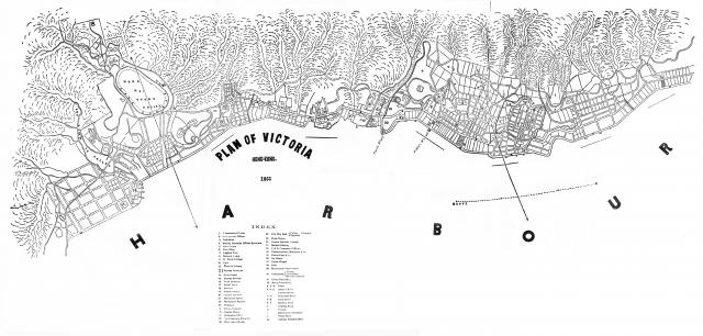
Victoria-Harbour - map of 1866

Victoria-Harbour - map of 1866

Here goes my second attempt at adding maps for David's new map project. The source this time is the 1867 edition of the Chronicle & Directory of China. Japan & Corea etc.,etc. Note that there are some minor imperfections in the street alignments in the area adjacent to Taiping Shan, Union Chapel & Hollywood Road ( marked as "37" & "D" respectively in the Index) . These errors (arising from page joints or paper folds) were present in the original microfilm reader printouts from which I have stitched this map together. Readers also note that the cartographer has not aligned this map in the conventional North facing direction.
Date picture taken (may be approximate): 
Monday, January 1, 1866

Comments

Another good addition, thank you. Here's the index to help people find it when searching by text:

INDEX.

  • 1.    Government House.
  • 2.    Government Offices.
  • 3.    Cathedral.
  • 4.    Murray Barracks Officers Quarters.
  • 5.    Court house.
  • 6.    Post Office.
  • 7.    English Club.
  • 8.    Zetland Lodge.
  • 9.    St. Pauls College.
  • 10.    Gaol.
  • 11.    Victoria Library
  • 12 / 13. Murray Barracks.
  • 14.    Main Guard.
  • 15.    Parade Ground.
  • 16.    Head Quarters
  • 17.    Naval Yard
  • 18.    Arsenal
  • 19.    Commissariat.
  • 20.    Cricket Ground
  • 21    Military Hospital.
  • 22    Wellington Battery
  • 23    Gunshed
  • 24 Native Hospital
  • 25 Engine House
  • 26 Ordinance Office
  • 27    New Seamens Hospital
  • 28    East Guard House.
  • 29. New City Hall: {Public Fountain Opposite
  • 30. Clock Tower.
  • 31. Roman Catholic Church.
  • 32. Central Market.
  • 33.    P. & 0. Company’s Offices
  • 34.    Messrs Jardine, Matheson & Co.
  • 35.    Messrs Dent & Co.
  • 36. Ice House.
  • 37.    Union Chapel.
  • 38.    Mint.
  • 39.    Racecourse Grand Stand
  • 40.    Cemetaries. -  Parsee. / Protestant / Roman Catholic
  • 41.    China Mail Office
  • 42.    Daily Press Office.
  • A. A. A. Praya.
  • B  B  B. Queen's Road
  • C           Public Garden
  • D D       Hollywood Road
  • E. E.      Caine Road
  • F. F       Bonham Road.
  • G          Hospital Road
  • H           Mosque.
  • I            Mahomedan Cemetary.
  • J           Water Tank.
  • K.          Harbour Master's Office

Tymon has found this map was also used in the 1867 edition of "The Treaty Ports of China and Japan. A Complete Guide to the Open Ports of those Countries, together with Peking, Yedo, Hongkong and Macao" It has been reprinted by Cambridge Press, and they have the maps (colour, hand-tinted) available for download in their "resources" section. The Hong Kong map is "Map 003: Map of Victoria", on the second page of the resources:

http://www.cambridge.org/hk/academic/subjects/history/east-asian-history...