The Adamastor Rock [????- ]
Primary tabs
Submitted by tung lin on Thu, 2016-07-28 13:51
Current condition:
In use
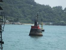
Hello folk, The Adamastor Rock, if without any man-made structure on it, is slightly below the sea level. It is quite visible through the shallow water during sunny day when you are close enough to it. It can stir up white ocean waves during tide times. A lamp beacon stand of concrete about 3 or 4 m tall has been built to alert the shipping traffic. The location is about 500 m east of the loose rocks at the east-end of the Chi Ma Wan Peninsula and about 900 m north of the nearest coast of Cheung Chau. By the way, this waterway along the south Lantau is called as the Adamastor Channel. A Portuguese location name again in the former British colony. isn't it a bit strange? Tung
Tags:
Photos that show this place
|
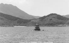
1963 |
 1970 |
 |


Comments
Chang Chow Passage Light
From List of Lights 2006 on the navigational beacon:
Chang Chow Passage, on Adamastor Rock between Lan Tau Shan and Cheung Chau Island. White concrete Tower.
Location: 22°13.0 N / 114° 01.1 E
From Lighthouses in Hong Kong pre-1941- revised
Before WW2 there were also significant navigational beacons –[....]and Adamastor Rock (first beacon 1899, first lit 1920 but repaired or replaced after typhoons in 1923 and 1937).
Adamastor Rock light
The beacon would have been painted in the isolated danger mark colours (red white and black band) of the old lateral system before being repainted white. In 2014, the beacon was repainted in red and black and a double black sphere topmark was installed. The light was converted from acetylene to battery operation in December 1968 and a radar reflector was installed later.
Exact location
The marker should be closer to Cheung Chau, see comment by tngan.