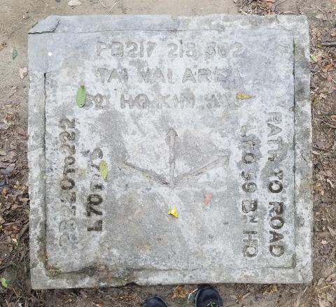
Direction slabs along the Gin Drinkers Line
Primary tabs
If you go walking in the hills behind Kowloon, you'll likely have seen raised, concrete slabs like these:
In this guest post, Rob Weir explains their background, and gives us a map of the 70+ slabs he's found in that area.
Introduction
The slabs were erected to help British troops find their way around a defensive system of trenches, lookouts and pillboxes, collectively known as the Gin Drinkers Line.
A document in the HKPRO (I think it was part of HKMS 100), dates their construction to late 1941:
"Some six weeks before the attack ….(back to working on the line) [my paraphrase]. To assist the service personnel in finding the scores of pillboxes, Coy & Bn HQ’s, food shelters, kitchens and the like, large square concrete blocks were erected giving directions by arrow and designation of the type of installation. They must have been perfect markers for the Japanese. Plotted them for a plan for WO after the war, they had no records”.
Signed: Alf Taylor, Senior Land Assistant, 6 Mar 1968.
It's not known if they helped the Japanese soldiers who attacked this area, but as Taylor's comment shows, that was the widespread belief. Another example comes from Sir Edwin Ride’s escape story, when he notes that "Just before sunrise the party came across one of the many concrete direction blocks" which he later remarked “we had kindly put all through the New Territories to direct the enemy to our pill-boxes, observation posts and headquarters”.
The slabs
You'll find square concrete blocks, set adjacent to the tracks that existed in 1941. Inset into the top surface is a concrete slab, with arrows pointing in the direction of annotated positions, but without the distance to that position. This distance can be as close as a few metres, or as far as several kilometres away.
These are the abbreviations used on the slabs:
- AA – Anti Aircraft Searchlight
- Bn HQ – Battalion HQ
- Coy HQ – Company HQ
- CP – Crown Point
- GP – Grasscutters Pass
- KH – Kin Hau
- KN – Kowloon
- L – followed by a number, sometimes with (L) or (R) – Lookout
- LL – followed by a number - Lyon Light Shelter
- PB – followed by a number - Pillbox
- Res Bn – Reserve Battalion
- RP – Railway Pass
- SP – Shatin Pass
- TP – Tates Pass
Their location
(E-mail subscribers will need to click here and view this page on the Gwulo website to see the map.)
I recorded these slabs' positions as marks on paper maps, mostly done during the 1990s. That was before GPS became widely available, so I apologise if the locations aren't always accurate. Also note that these days (2018) many of the tracks are no longer walkable, or may have been rerouted. That leads on to ...
Request for help
If you see one of these slabs, please could you click through to its page and leave a comment with the current condition of the slab, and its GPS location. If you can upload a photo of it, that will be very welcome too.
Please also let us know if you find any others that aren't listed here - but note that there are many other different types of markers in the area, put in place for waterworks, survey, electricity use, etc., going back to the early 1900’s.
Many thanks to Rob for sharing his research with us. You can find links to several more articles by Rob about Hong Kong's military relics at the page: Historic Military Buildings in Hong Kong.


