HEC quarters - Semi-detached building on land bounded by Electric Rd / Tin Chong St / King's Road [????-c.1959]
Primary tabs
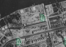
I think it stood roughly where the eastern end of Luen Wo Apartments and Nam Tin Building stand today. It was very close to the North Point power station, and @jjohnantonsmith notes it was "the duty engineer's quarters, where my father (Raymond Smith) and my mother (Pixie Smith) lived until his retirement in 1956; he cultivated the garden in front of the house."
There's a good view of it on map 1945.5 at http://www.hkmaps.hk/mapviewer.html - it was set at a different angle from the rest of the buildings in the area.
It would have been a noisy place to live, as at that time the trams made a 90-degree turn from Electric Road into Tin Chong St, which would make the tram wheels squeal.
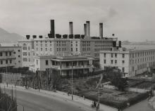
Raymond Smith's photos show the building suffered damage during WW2, and was repaired after the end of the war:

One of his photos from the 1950s shows the pitched, tiled roof had been replaced with a flat, concrete roof:

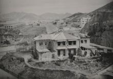
By the time this 1960s photo was taken, the building had been demolished and the small hill it stood on had been cleared away.

Photos that show this place
 1949 |
 1950 |
 |


Comments
Observations
A few observations of the map 1945.5 mentioned above:
1) The map information at best is from 1930. The district of Wanchai and its praya looks barren and Morrison Hill is in the course of demolition (1929).
2) The new road (King's Road) is not shown on the map. The road and proposed double tracking of the tramline from Causeway Bay to Quarry Bay are mentioned here .In the 1930s, the section of King's Road to Quarry Bay was built in stages and finally completed in 1936. Para 128 of 1936 PWD Report refers. I think in the post-war photo of the house on the mound (construction site), the tram tracks would have followed King's Road rather than Electric Road.