Gwulo: Old Hong Kong

Welcome

Welcome to Gwulo.com, and over 30,000 pages about old Hong Kong.

If it's your first visit, you might like to use the search box at the top of the page to find what you're looking for, check out the latest old photos, or just scroll down to browse through recent articles.

I hope you'll join in too, and share your questions and knowledge with us. Most pages let you leave a comment, it's easy to upload a photo, and the Forum is waiting for you to post a new message.

Finally, if you're interested in Hong Kong history, please stay in touch by signing up for Gwulo's free weekly newsletter.

Kind regards,

David

PS 'Gwu lo' is roughly how '古老' sounds in Cantonese. It means 'ancient' or 'old-fashioned'.
The Anglo-Chinese Boundary 1898

Guest author Klaus Liphard describes how the boundary between the New Territories and China was created in the 1890s.


Introduction

At the end of the 19th century, the Chinese Qing Empire was weak. This was utilized by foreign powers - France, Germany, Russia, and also Great Britain - to force China to lease territories to them.

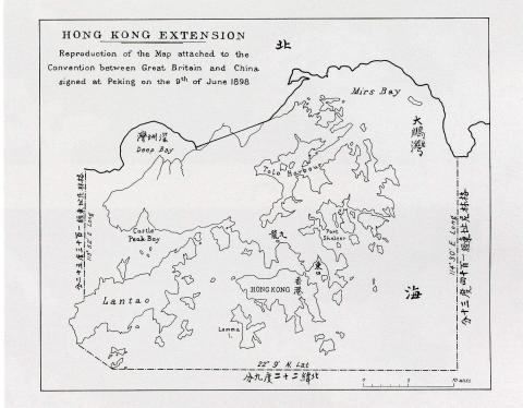
Britain forced China into The Convention Between Great Britain and China Respecting an Extension of Hong Kong Territory, also known as the Second Convention of Peking, which leased the New Territories to Britain for 99 years. The Convention was signed on 9 June 1898 in Peking (Beijing) and became effective on July 1st, 1898. This short convention (the English text is only one and a half pages) included a map showing the new boundary.

Map of Hong Kong in The Convention for the Extension of Hong Kong Territory in 1898
Map of Hong Kong in The Convention for the Extension of Hong Kong Territory
in 1898, by Klaus


This map had a small scale only. The eastern end of the boundary on land was at Starling Inlet (Mirs Bay), and the western one at Deep Bay. Between these two end points, a straight line was drawn. The exact course of the boundary had to be negotiated by

New on Gwulo: 2021, week 24

A look at what's new on the Gwulo website...
 

General


Places

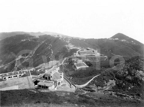
1890s View from the Peak

1890s View from the Peak


Where: As the title says, we're up at the Peak, looking out to the southeast with Mount Kellett over on the right. Here's a modern map of the area, with the red dot showing

New on Gwulo: 2021, week 22

A look at what's new on the Gwulo website...
 

General


Places

Delivering a one-ton load to the 25th floor - made possible by the RAF's 28 Squadron

In April 1972, Gordon Andreassend was sitting in his office in Murray Building when Hal Empson, the Cartographer strode in. “We’ve got a problem with the process camera” he said.

“Everything’s arrived, hasn’t it, what’s the problem?” was Gordon’s reply. 

It appeared there seemed no way to get the solid metal base of the camera, weighing about one ton, and 20 foot in length, into its allocated space on top of the building. It was too big for any lift, and too heavy to manhandle up the stairs to the 25th floor. 

Murray Building had been completed in 1970, and was the HQ and home to several offices of the Public Works Department (PWD). There was no

Pages

Subscribe to Gwulo: Old Hong Kong RSS