Everything tagged "map" | Gwulo: Old Hong Kong

Everything tagged "map"

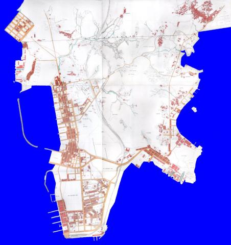
1920 map of Kowloon

This is a low-resolution copy. To see a high-resolution copy you can zoom in to, please view it in the map viewer: https://gwulo.com/map-of-places#14/22.3130/114.1770/Map_by_ESRI-1920_Kow...

For more information about what is shown in this map, please see the article at https://gwulo.com/node/49661 

1920 Map of Kowloon

A few weeks ago we looked at how the 1920 map of Kowloon was added to Gwulo. Today we'll take a closer look at the map itself, and see what stories it has to tell of early 20th-century Kowloon.

1920 map of Kowloon
1920 map of Kowloon


Tsim Sha Tsui (TST)

The start of the 20th century saw huge changes in TST. Here's how it had looked in 1896.

Ho Mun Tin watercourses in 1920

Date picture taken (to nearest decade for older photos): 
1920

Hill near Market Street / Nathan Road

Ho Mun Tin watercourses in 1896

Date picture taken (to nearest decade for older photos): 
1896

Map of Hung Hom in 1896

Date picture taken (to nearest decade for older photos): 
1896

Detail cropped from the 1896 map at https://gwulo.com/node/40904

Map of Hung Hom in 1920

Date picture taken (to nearest decade for older photos): 
1920

Detail cropped from the 1920 map at https://gwulo.com/node/49661

Hung Hom reclamation

Map of Mong Kok in 1920

Detail cropped from the 1920 map at https://gwulo.com/node/49661

Map of Ho Mun Tin in 1896

Date picture taken (to nearest decade for older photos): 
1896

Detail cropped from the 1896 map at https://gwulo.com/node/40904

Pages

Subscribe to Everything tagged "map"