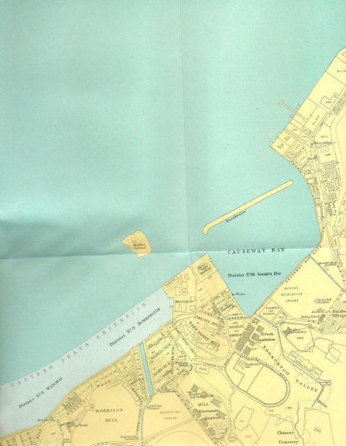
1920s East Point Map
Primary tabs

Submitted by moddsey
Date picture taken (may be approximate):
Thursday, January 1, 1925
Gallery:
Connections:
- 1920s East Point Map shows Place Causeway Bay Typhoon Shelter (1st generation) [????- ]
- 1920s East Point Map shows Place Smith, Wahee & Co. sugar refinery / China Sugar Refinery [1870-1928]
- 1920s East Point Map shows Place Leighton Hill Government Quarters (1st generation) [1921-1941]
- 1920s East Point Map shows Place Morrison Hill [????-c.1965]
- 1920s East Point Map shows Place Matheson's Bungalow - East Point Hill [????- ]
- 1920s East Point Map shows Place Queen's Recreation Ground at Causeway Bay [????- ]
- 1920s East Point Map shows Place Bowrington Canal [????- ]
- 1920s East Point Map shows Place Former #1 Police Station, Leighton Road [1853-????]
- 1920s East Point Map shows Place Kennedy Stables - Causeway Bay [????-????]
- 1920s East Point Map shows Place Belilios Reformatory [1900-c.1952]
- 1920s East Point Map shows Place Former Police Recreation Club - Happy Valley [????-????]
- 1920s East Point Map shows Place St. Paul's Convent School (original buildings) [1914-1979]
- 1920s East Point Map shows Place Sir Ellis Kadoorie Primary School - Sookanpo [????- ]
- 1920s East Point Map shows Place Causeway Road: The 'Causeway' in Causeway Bay [????- ]
- 1920s East Point Map shows Place Wong Nai Chung Road Government Quarters [????- ]
- 1920s East Point Map shows Place Whitfield Police Station / Bay View Hotel / Bay View Police Station - 20 Shaukiwan Road [????-????]
- 1920s East Point Map shows Place Dutch Oil Company [c.1897-1981]
- 1920s East Point Map shows Place Yee Wo Street, Causeway Bay [1902- ]
- 1920s East Point Map shows Place Craigengower Cricket Club [1922- ]
- 1920s East Point Map shows Place Wanchai Gasometer [????-????]
- 1920s East Point Map shows Place Ice Works Causeway Bay [c.1874-c.1974]


