AOP, Middle Spur [1939- ]
Primary tabs
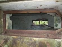
Here are notes and video from a recent visit to the wartime Artillery Observation Post at Middle Spur, overlooking Deep Water Bay and Repulse Bay.
Video of Middle Spur AOP today
Middle Spur in the fighting, 1941
Here are mentions of the area in Tony Banham's book, 'Not the slightest chance':
- 19 Dec, 15.00: The ordered counter-attack on the Japanese beachhead is attempted. [...] B Company of the Winnipeg Grenadiers is ordered to advance across the Gap eastwards in a line running from Sir Cecil's Ride to Middle Spur.
- 19 Dec: At night, Japanese forces move south as far as Gauge Basin, Stanley Gap, Violet Hill, Middle Spur, and even Shouson Hill, and occupy the garage of the Repulse Bay Hotel.
- 20 Dec: Wallis wrote "When I told the G.S.O. 'I' early on 20 Dec that I considered the enemy were in the VIOLET HILL-MIDDLE SPUR area in some strength (probably a [battalion] and mortars) he seemed astonished and incredulous."
- 20 Dec, 10:00: It is clear that the Japanese are passing round and over Violet Hill, and are already on Middle Spur and in buildings south west of the Repulse Bay Hotel.
- 20 Dec, 10.45: The Middle Spur OP [ie the building we visited in the video] is reported surrounded, [...]
- 20 Dec, 11.00: [...] The Royal Rifles' party then attack over the hills towards Wong Nai Chung Gap, but make no headway (via the catchments) towards their objective of Violet Hill, or even Middle Spur. [...]
- 20 Dec: Two 18-pounders of the 965 Defence Battery under Second Lieutenant E. G. Phillips help infantry around Repulse Bay, firing over open sights at enemy on Middle Spur and Violet Hill. Four mortars are destroyed, and many casualties observed.
- 21 Dec: In the afternoon, the Navy gives what help it can. [HMS] Robin fires fifty rounds of 3.7-inch howitzer at Middle Spur, [...]
- 21 Dec, 17.00: Major Templer arrives at the [Repulse Bay Hotel] to take command of all forces around Repulse Bay. He leads A Company Royal Rifles, driving (via Eucliffe, with only three lorries reaching this point thanks to fire from Middle Spur) [...]
- 22 Dec. In the south, Repulse Bay comes under heavy mortar fire from the Japanese on Middle Spur.
By the end of 22nd Dec, the Japanese were in control of the Repulse Bay Hotel, and the area around Deep Water Bay. The fighting in this area moved down towards Stanley, and there are are no more mentions of Middle Spur.
Questions
Were the Royal Artillery soldiers manning the AOP able to escape before they were surrounded?
Was the trench dug by the Japanese or British forces?
Was the trench intended as a place to fight from, or mainly for communication between the larger rectangular areas? I wonder if those larger areas housed the Japanese mortars that were mentioned several times in the accounts of the fighting.
The service reservoir near the trench appears on a 1949 map (Mapping Hong Kong, plate 2-13). Was it already there before the war?
Does the concrete path between AOP and concrete shelter date from the wartime?
Getting there
We used the Countryside Series map for Hong Kong. Starting from the Wong Nai Chung Reservoir, follow the path south along the catchwater on the western slopes of Violet Hill. You'll see the map shows the path heads south, then turns east . At the point it turns, there's a dotted-line path marked heading in an 8 o'clock direction down a ridge. That's the path we followed.
It follows the line of telephone cable. You'll see the older, metal-sheathed cables,
and occasional newer plastic-sheathed cables where the ground has been washed away.
At the bottom of the slope you'll see the trench as shown at the start of the video.
Getting out
With hindsight, I'd recommend retracing your steps back up the hill to the main footpath.
First we tried following the concrete path you see at the end of the video. It carries on for a good distance, without getting too badly overgrown. But eventually it was heavily overgrown, and we could see steep drops nearby. We turned back and tried the opposite direction.
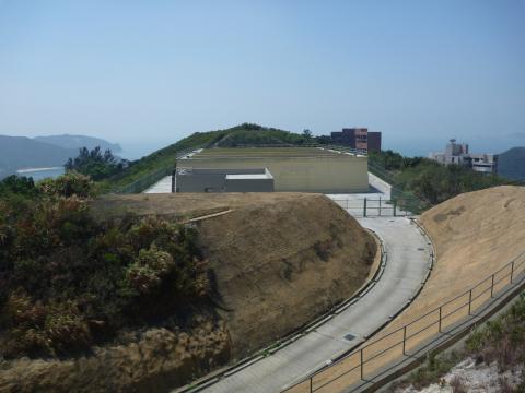
That took us across the small reservoir, and along a concrete path around the hill. It brings you out to this bigger, newer reservoir, and a road.
End of problem? Seems that way, but we follows the road down and ended up at a big gate & fence, with barbed wire along the top. So back up the road to the big reservoir...
Finally we just crashed downhill through the undergrowth (roughly following the line of a large pipeline) till we hit the public road. Again, it would have been quicker and easier to just walk back the way we'd come. Safer too, as there are some steep drops where the road has been cut into the hill.
Thanks very much to Rob Weir for joining me on the walk, and showing me where this AOP is.
If you have any more information about the AOP, I'm very interested to hear from you. Please leave a comment below.
Regards,
David

Comments
David,Where is AOP in
David,
Where is AOP in relation to the pipe? Where is the trench?
I was there with my little girl just 2 weeks ago, started at the top and walked down the trail. Eventually we hit the pipe and followed the pipe (walking on top of it at times) and had a pleasent walk into Belleview Drive (see openstreetmap for our path trace). No need to go back up; if you find the pipe, just follow it all the way down. Its not bad at all compared with the upper part of the path.
I didnt notice any concrete paths, trench nor any structures, but then again I had no idea there was anything to look for. Would love to go back and look some more if you could give me an idea of approximate location in relation to the pipe? Is there a path from the upper water reservoir? If you have precise co-ordinates or breadcrumb trails from a GPS, that would be very helpful.
http://www.openstreetmap.org/?lat=22.24054&lon=114.19313&zoom=17
BTW, was the the gate/fence with the barbed wire:
http://maps.google.com/?ie=UTF8&hq=&hnear=Hong+Kong&ll=22.239819,114.191...
TonyB
AOP / Pipe / Trench
Hi Tony,
Just getting ready to leave on a trip and will be away for a couple of weeks. When I get back I'll see if there's a way to link your GPS trails into our markers, so it's easier to match them up.
We're talking about two different pipelines. I can see the one you describe on the map, but unfortunately we didn't try that one, as it sounds like a much better path! We followed a different pipeline (also visible on the countryside series map) that runs down the north side of the spur.
If you follow your pipeline up til it hits the smaller upper service reservoir visible at 1:02 in the video, then walk east from that service reservoir and you should fall into the trench!
Yes, that's the same gate with barbed wire.
Regards, David
Middle Spur
I went there with Craig (fellow Gwulo enthusiast) on Saturday - we found a number of Japanese machine gun rounds fired from a firing pit off to the left in the first trench you come to. Probably firing on RBH or possibly at the trenches due South (immediately south of the reservoir). These trenches are hidden and deep and we found a British WW2 Helmet just sitting on the lip of the trench badly rusted but recognisable. We also found British 303 rounds (1) Royal Laboratories Woolich Arsenal 1932 and (2) GB 1935 (Greenwood and Batley ?). We also followed the path down to the gate (which is high and has barbed wire at the top) but we managed to climb over in the corner using a tree for assitance and to the surprise of a nearby Philipino driver.
re: Middle Spur
Phil, glad to hear you found the site ok, and interesting to hear about the evidence of both British and Japanese firing from the area.
The path south from the older reservoir skirts a small summit to the right of the path. Are the British trenches in that area?
Were there any British items found along the long trench shown in the video? If not I'll guess it was dug by the Japanese when they had control of the area, and was used for communication between the larger rectangular areas.
Regards, David
Middle Spur.
Hi David,
We had a good couple of hours around middle spur, and it did get pretty hot.
The Japanese 7.7mm Machine Gun shells were all found in the square dugout at the end of the trench, I didn't find anything in the other square hole halfway along the trench. Phil found a few British .303's just as the trench bends around towards the AOP, in front of the reservoir.
The other trenches, where the helmet was located, was on the other side of the reservior around the small peak, which David discribes. There were also a couple of similar bigger square dugouts along that trench system too, although we didn't manage a proper look around as we were about to leave.
I'm stilll cleaning up a few items I found in the second trenches in a big square, they might be able to tell us whom occupied them?
Apart form a couple of other bits of shrapnel and bits of fuze, not a lot else was in that area, which would expect to find more in.
Middle Spur
Hi Craig,
Thanks for the extra info. Interesting to see how your finds can help fill in more information about who was fighting at these old sites. Obviously it's quick to distinguish between Japanese and British items, but how much further detail about the troops present can you generally work out?
Regards, David
New Tracks added to Middle Spur
For those who would like to visit this site and dont feel like jumping the 8ft fence, I have mapped out a couple of alternatives starting from the south east, Belleview drive.
http://www.openstreetmap.org/?lat=22.240816&lon=114.192011&zoom=18&layers=M
There is always the path from the north east, starting from Tsz Lo Lan Shan Path and there is yet another path from the north west starting behind Twin Brook. This last one is not recommended as it is severely overgrown and I could not crash thru it. Will need to go back with some big knives to open this path up.
TonyB
Middle Spur AOP
In his post of 14-4-2011 David asked if the Service Reservoir infront of the AOP was built before the war.
The two photos said to have been taken in 1938 at http://gwulo.com/node/20616 & http://gwulo.com/node/20617 both show Middle Spur in the background above Repulse Bay. There's an artificially flat area where the Reservoir now is, strongly suggesting it was there in 1938. Sheet 19 of the 1939 1:20,000 OS map corroborates as Middle Spur bears the labels "Resr", probably short for "Reservoir", and "Pipe Line" in approximately the correct places.
This AOP is unique amongst the ones I've visited in that it was constructed in a location from where its view directly out to sea is blocked by the hill infront, i.e. the one on the opposite side of the Reservoir. As noted on the soundtrack of the video, its observation slits look out sideways, over Repulse Bay and Deep Water Bay raising the possibility that the role of this AOP was specifically to observe, and bring fire down on, the Bays and their beaches in the event of an enemy landing, rather than on ships further out at sea which the other south facing AOPs (Stanley Mound & Matilda) were able to do. Although the hill in front blocked much of the AOP's view, it would result in it being more difficult to see and target from the south.
Trenches facing each other on opposite sides of the Reservoir is another strange feature.
Update
Went to this location last week after failing to find it last year... We actually used a maintenance trail from Repulse Bay road up to the main reservoir + road. We went to the top of the maintenance trails at the top of the ridge above that road and semi-bush wacked a number of overgrown trails that eventually got us to the small service reservoir+AOP (we didnt realise the other trail swinging around the side existed). On these trails there were a couple more trenches that were smaller, you all saw i think
The bunke is being used as a construction storage for now it seems, but there was a gold mine of potential relics in there as well.
Middle Spur AOP
Hi Iloveoldhk,
Is the old lamp you found the same one as shown briefly in the top right corner of the screen at 4:41 in David's video posted above?
I visited this AOP, and the concrete bunker behind it, in 2013. The bunker seemed to have even more junk in it than when David filmed his video. Good luck to you if you plan to sift through it all for relics, but I'd certainly be interested to hear about what you find.
Yes! it does seem to be that
Yes! it does seem to be that one.. Was just hanging there on the wall. It seems to have markings on it from the 50s though, not 40s/30s slightly saddening. We went around a bit in there, but there were plenty of rats and such a thick layer of construction materials that it was hard to find anything good.
Might go back soon though!
Just curious, but did you find anything while you were there? or anywhere else for that matter. I hope to get a metal detector soon, but I have had very little luck so far. I am desperate for some simple memorabilia. Finding a cartridge would be the world to me
Thanks
Finding Stuff
Rats, aw yuk! Another thing to add to the list of nasties to avoid whilst out gwuloing. Nope, I didn't find anything here. In fact I've never found anything anywhere.
Middle spur'
The name 'Middle spur' is identified as early as 1913 on the map here http://www.hkmaps.hk/mapviewer.html that 80s kid opened my eyes to.
Middle Spur in Chinese
If you ever come across an
David,
Excuse me. I am unable to find any link to your video in your first post.
tonyb,
Is this the exit to Belleville Road from the pipe? If yes, then it's already blocked now.
3 麗景道
https://maps.app.goo.gl/rQErHz6h2uLVh7FA6
acklbbc,
If you ever come across an old grave in that area, you may find the Chinese name of the place on the plaque.
I've updated the link to the
I've updated the link to the Youtube video so it works again.