Bank of China Building / Central House / Kai Ming Building [1921-1980]
Primary tabs
Submitted by Admin on Fri, 2013-06-14 17:09
Current condition:
Demolished / No longer exists
Date Place completed:
1921-01-01
Date Place demolished:
1980-01-01
Building on western corner of Duddell Street / Queen's Road Central (QRC) junction. When it was built this site was 4, QRC. In the 1960s the road was re-numbered and this site's address changed to 10, QRC.
Photos that show this place
 1925 |
 1930 |
 1941 |


Comments
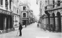
It's the first building on
It's the first building on the left in this photo:
Any information welcome.
Regards, David
Re: Building
On a 1959 BOAC Street Map of Central, it is listed as Central House.
Central House
I did a search on its old address, 4 Queen's Road Central, (view online) that turns up some more names:
Re: 4 and 6 Queen's Road Central
HKGRO PWD Annual Reports
The previous building at 4 Queens Road Central was demolished in 1919 with a new one erected in 1921. It appears to have been known as the Bank of China Building.
The building at 6 Queen's Road Central was completed in 1922.
Thanks Moddsey, I've added in
Thanks Moddsey, I've added in the completion date, and made a guess at 1980 for the demolition date, based on the next building on this site.
Please can you give a link to, or name of the HKGRO document you found this in?
Regards, David
Another name change
Thanks to Alan for pointing out that in the 1960s, maps show this as "Kai Ming Building", eg: http://gwulo.com/atom/12699
Regards, David
Central House & Kai Ming Building
First I thought these were two names for the same building, but a post on Uwants (thanks to Jessica for the link) shows them as adjacent buildings: https://www.facebook.com/photo.php?fbid=10204712365182434&set=p.10204712...
This 1959 map agrees, and also shows them as adjacent buildings, numbers 4 and 6 QRC:
But then this 1960s map confuses things:
It shows the outline of two buildings, but just a single name and number: "Kai Ming Building HK-60". I'm not sure if the two buildings were combined into one around then, or if it is just careless numbering on the map. Does anyone remember the Central House name lasting into the 1960s?
Regards, David
1950 - Another Central Map