Japanese tunnel below Sai Wan Redoubt [c.1944- ]
Primary tabs
Submitted by David on Wed, 2016-12-14 13:34
Current condition:
Ruin
Date Place completed:
c.1944-01-01 (Year, Month, Day are approximate)
[2020 Update: Marker position updated with correct coordinates from H Lo.]
Position of the marker is approximate, but it is on the path from the redoubt down to the hairpin bend in the road. The path is shown clearly on the OSM map.
Tags:


Comments
This tunnel and that of
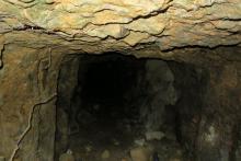
This tunnel and that of https://gwulo.com/node/35599 are the same system. Cuts through the whole side of the hill (~100-200 meters), I explored it all. Links with the gated entrances along the access road. Very large system, with this opening to hold potential large caliber guns. In addition, It has a series of features I have never seen before. Seperate tunnels off the main tunnel that lead to large, hollowed out rooms and alocoves. Very interesting.
That's a surprise - good to
That's a surprise - good to know. The view into this tunnel looks as though the rock is more solid than the stuff at Jardines Lookout, which collapsed in the large caverns. Were there many collapses in this one?
Rocks/vs/Clay
Yes. So this one is mostly rock. You are correct that there were less "full collapses" but there is still plenty of debris where the rocks fall from the ceilings and pile up. You can actually see the places where the rocks fell from on the ceilings. So unlike the clay tunnels where a collapse is usually complete, the rock tunnels do seem to stay more intact.
Note- The last times i have been in tunnels this summer, many have been mostly full with water. Especially at Jardines L. where the SW tunnel system's access to the 2nd level is completely flooded. (you can access the second level by bushwaking from the path however). The tunnel on this thread however is somewhat downward sloped, so this problem is not apparent.
- You may also be interested to hear that I did make it through the small opening into the cavern at the SW slope tunnel on Jardines L. it is another 4 way tunnel junction with one (15 meter) dead end tunnel accessible within the cavern and 2 more possibly accessible. The amount of loose clay piled up in the junction was insane though, and really scared me with the possibility of collapse. Anywho, the point is that there is actually quite a bit still on that 3rd level but I dont think it is safe to access.
Regards
Couldn't locate this one on
Couldn't locate this one on that same day when I came across the other two. Is this further away from the path?
Same as marked
Hi H. Lo,
Judging by location and the pictures, I believe the one you found and marked IS infact this one. I think I posted an explanation on your location tag.
Additional notes
(I've moved them here to keep all the information together.)
Submitted by H Lo on Thu, 2020-11-26 12:50
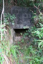
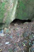
Collapsed inside, couldn't enter it. Looks like someone is doing the clean up, maybe one day we can venture inside again.
Found my old photo taken at the same place in 2017, the ground level was higher up, ie, up to the bottom of the entrance, so there must be someone digging up and removing the soil in front of it. There's no corrugated board on the ground, the vegetation almost covered up the entrance at that time.
Submitted by Iloveoldhk on Fri, 2020-11-27 03:34.
So this is the previous shield for a supposedly large caliber gun. Right above this is the entrance to the tunnel, a bit collapsed but still accessible. There is also a twin opening next to it further along. It opens up very large, similar to the the large on Jardines lookout and then narrows, but ends up running all the way through the ridge to the road. It actually connects to the gated up entrances on the road. Hundred or so meters in length is my guess.
My Coordinates
22.2716763, 114.2351734
The one I found was on the other side of the path at a lower altitude. Don't know if they are connected since I can't find yours while the one I find isn't safe for entry so far. Looks like someone is removing the soil from the tunnel, if it's not a mudslide ... hope we can take a tour inside someday.
I checked my old photo of the same tunnel to find it covered with more vegetation and no corrugated board in front ... The bricks also look as if they have been washed purposely ... Or maybe only the moss have been removed?
re: My Coordinates
Thank you, I've updated the marker to the position of your coordinates.
Although the marker has been
Although the marker has been updated as mentioned, it still rests on the west side of the path, which made me doubt if the path on the base map was incorrectly drawn ...