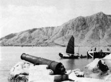
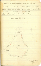
Kadoorie Beach, Tuen Mun, 18-3/4 Milestone [????- ]
Primary tabs
Submitted by tngan on Mon, 2008-11-03 15:10
Tag location corrected. Believe me or not, I managed to dig out a map dated 1990 with the right information. Back then before the Golden Coast was developed there was the Gordon Hard & the Perowne Barracks in the So Kwun Wat area. No wonder they have a military coach going to and from the city area.
T


Comments
Good lord - is this the same
Kadoorie Beach
Hi there,
I have to consult the aerial photo book of 1964 later tonight to get the exact location. The shoreline today is certainly not the same.
T
The tag on the map needs
Eleven and a half mile beach
Re: Eleven and a half mile
Hi there,
If you have a decent road map of Kowloon and the New Territories, you should be able to find the approximate location by measuring the Castle Peak Road from it's starting point in Sham Shui Po in miles. I doubt the 11.5 milestone is still there after all these construction works.
Anyway, Google Earth's ruler function might work just fine. Just zoom it in.
T
Re: Eleven and a half mile
Hi there,
Just measured it using Google Earth. Considering part of the existing Castle Peak Road is not following it's previous route, Eleven miles and a half should be roughly around the Tsing Lung Tau area.
T
Kadoorie Beach et al
Dragon Beach
In the '50s we used to go to Dragon Beach. Was that also known as Kadoorie Beach? It was certainly in that area.
D
Re: Dragon Beach
It was a bit further east. You can see a map & photo here.
Regards, David