Abandoned cemetery on south-east slope of Mount Davis [1856- ]
Primary tabs
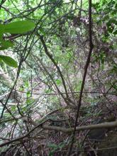
We found this while crashing through the undergrowth above Mount Davis Road. Here's the first stone we saw, which Thomas says indicates a mass grave:

There was also this grave, which was the only one we saw that is still visited and maintained:

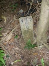
But most of the graves were just marked with very simple stones, simply showing a number. There are lots of them, here are a few:


They reminded me of this photo from Stephen Chadwick:

He took it in the 1950s, when he was stationed in the RAF facility at the top of Mount Davis. He wrote:
Grave believed to be war time. [...] We found numerous graves and tunnels dug into the hillside. These were discovered after a brush fire on the mountain.
The wartime explanation would be a reason for the simple gravestones. However they're actually a fair bit older than WW2.
I searched for davis cemetery in HKGRO, and found several mentions:
- 1892, Report of Sanitary Superintendent: "18. The following are the number of burials which have taken place up to the 31st December 1892, in each of the public Cemeteries for Chinese since they were placed under the charge of the Sanitary Department in February, 1892, viz:-". Then there's a list of cemeteries, with Mount Davis showing 547 burials in those 10 months. It was the busiest site, as next was "Kau-lung Cemetery" with 321 burials.
- Then there are similar mentions of the cemeteries in following years' reports. eg the 1905 report mentions "5 new terraces have been formed in Sec. C. of Mount Davies [sic] Cemetery".
- 1906. The cemetery is closed: Item no. 691 in the Government Gazette for 17 Aug 1906 announced "that the Mount Davis Cemetery shall be closed on or after the 31st day of December, 1906."
- 1914. Some of the graves are cleared. Two items in the gazette announce graves are to be cleared. First is item no. 331, "directing the removal of all graves on Inland Lot No 2080 being formerly part of Mount Davis Cemetery [for the purpose] of the sale of land for building purposes." IL 2080 is the site of On Lee, between Mount Davis Road and the remaining graves.
Next came item no. 449. It has a similar explanation, though for inland lot 2090. Today the Geoinfo map shows Greenery Gardens and Four Winds Apartments on that site. The clearance was justified as required for "public purposes, namely, the sale of land for building purposes and the construction of a Military path."
There are a couple more pre-WW2 mentions that graves would be cleared for building work in the area. It looks as though there are still many graves that were never removed. I wonder if the records still exist to show who was buried at each of those numbered graves?
Regards, David
Photos that show this place
 1895 |
 2012 |
 2012 |


Comments
Re: Old graves
Hi David,
While browsing cache.org.hk I found this. Please take a look at item 7. There are two photo of another grave with the same engraving of 義塚. Cache mentioned this particular one was established by Tung Wah Group of Hospitals long long time ago and is close to Kwun Lung Lau. They called it 牛房義山義塚.
The name 牛房 seem to be where they impound the cattle before running them through the slaughter house. 義山 would probably mean the whole hill was for similar use where 義塚 is either a mass grave or graves with no names, like we saw the other day.
義 in this case could mean something similar to charity. There is no exact translation though.
Best Regards,
T
"Charity graves"
Just reading the words off the 'maintained' grave. The top four words, read vertically from right to left, is '四會廣寧', which corresponds to the areas of 'Sihui' and 'Guangning', about 50km northwest of Guangzhou city.
The larger words down the bottom '先友之墳', roughly translates to 'grave of friends who passed away'. To me that corresponds to a regional grouping burying their fellow villagers in this grave, which meant no family member was there to pick up the remains.
I concur with T that this seems like one of those Tung Wah group cemeteries that as a charitable service buried them. Obviously the people buried here fared better than those under non-descript numbered gravestones.
breskvar
re: "Charity graves"
Thanks Thomas & Breskvar, I agree the "charity burials for people without any friends / relatives who'd send their remains back to their home town" explanation seems most likely.
Regards, David
Where can I find these?
Dear David
Can you tell me more about the location of these graves? How can I get there? Guess it's not the one that T mentioned? (somewhere behind Kwun Lung Lau), they're located at two differenct places? Thanks.
Cattyhk
Getting to the abandoned cemetery
Hi Cattyhk,
If you look at the top of this page, the red marker on the satellite view shows roughly where we found the graves. They're buried in the undergrowth, so it's quite a scramble to find them.
We started off on Mount Davis Road. If you look at the section of road between On Lee and Greenery Garden, you'll see there's a short spur of road that looks like it runs into Greenery Garden. When you get there you'll see it's a ramp, but that it runs to a dead end. (Mr Chan believes it was built as a place where parties bringing coffins to the cemetery would wait before taking them to the cemetery. I'm not sure, and wonder if it was the old entrance road to whatever building used to stand on the site of Greenery Garden.) Anyway, we crossed Mount Davis Road where the ramp is, then followed the outside of the boundary fence that surrounds Greenery Garden. If you head up the hillside that's behind the Four Winds building, you should find plenty of these graves.
Can you tell us anything more about their history?
Regards, David
mount davis cemetery
So early that cemetery (no.71) was if the below was talking the same place you visited.
http://hkgro.lib.hku.hk/archive/files/f16ce16c2ffeec26f0ee37362a3ef42c.pdf
Re: Mount Davis Cemetary
Hi there,
Apparently so. I found a Chinese entry on the web mentioning about the Chinese Cemetary at Mount Davis was located somewhere near the 'Four Winds/恆琪園' on Mount Davis Road today. The Four Winds is just a few hours away from where we started the other day. I could not verify to what extent did the so called cemetary cover Mount Davis. We need some really old maps or goverment papers showing clearly the cemetary lot to be certain.
Best Regards,
T
Re: Mount Davis Cemetery
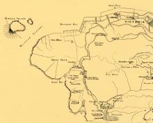
Thanks to @LittleGirl, that's a good find. Here's a map of the area from 1895:
Just below and to the right of the text "MOUNT DAVIS", you can see this cemetery's location is marked (it's a bit small to read - you can click the map for a copy you can zoom in on). That doesn't prove it was here since 1856, but it seems likely.
I also had an interesting email from Henry Ching about the cemetery:
During the occupation ((ie the Japanese occupation of Hong Kong)) we visited a friend of my father’s who had a farm at Mt Davis. It was, I think, on Mt Davis Road. The friend’s name was Landau (but I cannot be absolutely sure). In working his farm he had dug up a number of remains, and had quite a collection of bones. I listened in fascination to his conversation with my father in which reference was made to these being the remains of plague victims. It was the first I had heard of the plague in HK.
E.G.Pryor wrote an article on the plague, and says that many of those who died were buried in a plague cemetery in Kennedy Town. The Glass Works Hospital, used for plague victims, was of course in Kennedy Town, but I wonder whether Pryor meant Mt Davis rather than Kennedy Town as a burial place.
It's certainly possible that plague victims were buried in this cemetery, however the map above shows there was a specific area for plague burials a bit further south. It's marked "The Plague burial ground (1894)" on the map.
"Landau" may be Aaron "Jimmy" Landau, owner of Jimmy's Kitchen and Parisian Grill restaurants. That would explain him owning a farm. Post-war there was a "PG Farm" owned by the same family and named after the Parisian Grill, but located where the "lowland" part of Ocean Park is today.
I think I've read there was also a plague cemetery on the north slope of Mount Davis, near to Kennedy Town.
Regards, David
Re: Mount Davis Cemetary
Hi there,
The location appear to match where we trasspassed on. :-P
On the other hand, there is a Restaurant called Landau's. Don't know if it has anything to do with this Landau individual or family as well.
Best Regards,
T
Hi David Thanks very much
Hi David
Thanks very much for your guidance. I tried last Sat but I couldn't make to the grave area (too bad!!). I found there's only one spur between the resident entrances of On Lee and Greenery Garden, but it's really look like a dead end and I had to elbow up and fight off all those tree and grass. I was just by myself and felt like I was a trespasser!! and I quit.....!! then I turned trying enter from On Lee resident entrance, I walked up to the houses, couldn't find anyway cross to the ramp that you talked about (luckily no security guard came out and queried my purporse). When I searched google map again that nite, I pretty sure that's the only way I could get through, I must give one more try over the weekend. Also, I remember there was a Landau on Gloucester Rd (CWB, very close to Excelsior Hotel), don't know if it's owner also owned Jimmy's Kitchen, it was a few decades ago, don't know Landau or Jimmy's Kitchen came first?
Best Regards
CattyHK
Re: Mount Davis Cemetery
Hi there,
The spur/ramp you initially went up is the correct one. For a short while we were going along the wire fence for a few minutes before turning a bit away from it and into all the vegatation/undergrowth/trees. Some of the graves were not too far away. What we saw last time were likely empty graves but some of the stones are intact, still in position.
It would be unwise to go alone. Last time I have to stop and untangle myself every few steps. For a few times I need assistance as I could not reach back far enough to get those vines from my backpack.
Best Regards,
T
We may find the Boundary for the Mount Davis Cemetery??
AS we found the map for the Mount Davis WAR Department Stone CO129/402 , we find some thing interesting, it show a boundary and Boundary stone cross the Mount Davis, as we come to the site, we find The "Military path", our friend Danny Lee find one 8 feet obelisk near CHIU Yuen Cemetery and I found one collapsed 10 feet obelisk! we may go back for more info. this week!!
That's an unusual boundary,
That's an unusual boundary, running over the top of the hill and splitting it in half.
Do the obelisks have any writing on them?
Tung Wah Hospital group charity mass grave
The charity mass grave at the slaughterhouse area on Smithfield Road was moved to Wo Hop Shek in 1983.
we find 4 8 to 10 feet Obelisks without any marking!!
Find one More Obelsik, Total 5 now
Mr. Chan Chun Fai remind us, he find one more Mount Davis Cemetery Obslisk near IL8122 Boundary stone at chiu yuen cemetery
Great finds!
And the government notification from 1884 makes their purpose very clear.
Mount Davis Obselisk