Former Hung Hom Ferry Pier for Hung Hom / Central service [1965-c.1971]
Primary tabs
Submitted by tngan on Wed, 2013-01-16 12:41
Current condition:
Demolished / No longer exists
Date Place completed:
c.1965-06-01 (Day is approximate)
Date Place demolished:
c.1971-12-31 (Year, Month, Day are approximate)
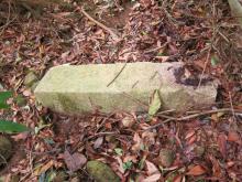
The present day foot bridge stands more or less along the old sea front. We could use the bridge as a reference for the three piers.
According to a Wiki entry the Central/Hung Home service was formerly run by HYF in 1967. But service was suspended owing to the riots and did not resume. Star Ferry took over later. I have seen an old photo showing a HYF ferry tied to this pier somewhere at Uwants.


Comments
history of hunghom-central service
The hunghom-central service started in 1965. A newspaper report with picture indicates it was under construction that year By the way that Wiki entry is incorrect as the news report says the Star Ferry ran that service to Central in 1965. Of course Star Ferry used the left wing of their Central pier for TST and the right wing for Hunghom.
=================================================
=====================================================
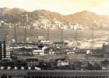
An aereal photo showing the 3 piers at hunghom in 1965
==========================================
From left to right: to Central, to Wanchai, to North point
===================================================================
It is true that star ferry company suspended the service for the reason you stated. It did resume in 1975 when the new hunghom train terminal was opened in 1975 according to the following news report. By that time, the original pier had been demolished. They had to borrow the wanchai service pier from HYF which had to combine the Wanchai service and north point service at the righmost pier.
===========================================
==========================================
What happened in 1979 was that HYF built a new pier for their Wanchai and north point lines at approximately the position of the 1965 Central pier while abandoning the original pier (rightmost pier in above picture). Picture of that new pier can be found at gwulo.
In 1988, that part of coastline was again reclaimed, all the piers there were moved to Hunghom Bay center.
By the way you still can see the 1979 pier on the map just north of the railway station.
=========================================
==========================================
In 1991, again because of reclamation the piers were moved to Whampoa Garden.
These three piers are shown
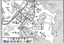
These three piers are shown on Map 1970 at https://www.hkmaps.hk/mapviewer.html
I've used that to adjust the locations of the three markers:
https://gwulo.com/map-of-places#18/22.30508/114.18347/Map_by_ESRI-Marker...
I've also updated the status of the three Places to 'demolished'.
T, is it ok to delete the '(1979)' from the titles of these three Places?
hunghom piers
David:
It is indeed a long story. If you are referring to the following map, it shows the two piers at Whampoa Garden after 1991. The left one going to Central and right one going to north point. By checking Google map, the Central line apparently is no longer active. I can't find any 1970 map at your link.
The labels of the 3 markers are not quite correct. As mentioned above, in 1979, HYF built a new pier for their Wanchai and north point lines. Picture of that pier can be found on Gwulo (https://gwulo.com/atom/15937) (the label "Turntable-Tsim Sha Tsui East" is obviously wrong).
========================================================
Former Hung Hom Ferry Pier (1979) for Hung Hom / North Point service [????-????]
should be something like Former Hung Hom Ferry Pier for Hung Hom / North Point service [1963-1979] and Hung Hom / Wanchai service [1975-1979]
In 1963, after reclamation, the hunghom coast line was moved from Gilles road to Whampoa street. The north point pier was moved to this marker position. A new ferry pier for Wanchai line was built south of this marker. As mentioned above, in 1975 the wanchai service was moved here because the pier for wanchai service was rented to Star ferry for their Central line. In 1979, Both lines were moved to the new pier.
========================================================
Former Hung Hom Ferry Pier (1979) for Hung Hom / Wanchai service [????-????]
should be something like Former Hung Hom Ferry Pier for Hung Hom / Wanchai service [1963-1975] and for Hung Hom / Central service [1975-1988]
Pier at this marker was built in 1963. In 1975, this pier was rented to Star ferry for their Central service. In 1988, the Central service was moved to a temporary pier at Hunghom Bay Center.
============================================================
Former Hung Hom Ferry Pier (1979) for Hung Hom / Central service [????-????]
should be Former Hung Hom Ferry Pier for Hung Hom / Central service [1965-1967]
and Former Hung Hom Ferry Pier for Hung Hom / North point and Wanchai services [1979-1988]
The pier at this marker was quite short-lived and was demolished sometime after 1967. Another pier was built here in 1979 for Hung Hom / North point and Wanchai services which only lasted until 1988 when the sevices moved to Hunghom Bay Center.
==================================================
Re: Present day Hung Hom\Central Line
Hi There,
There is indeed a current ferry route between Hung Hom and Central. It's just that it is not operated by Star Ferry. It is operated by CMS. The Central side is using the westen side of the Museum though.
T
hunghom piers pictures.
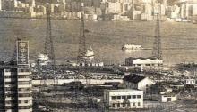
Here are three pictures. First two pictures showing the pier used for the Central service from 1975-1988 (which originally belonged to HYF for their Wanchai line from 1963 to 1975). The ferry boat is silver star of star ferry. And the pier clearly had the words "star ferry to Central" displayed on its side wall. The third one show the 1979 pier built for both the northpoint and wanchai services. One can see part of this pier in the second picture behind the star ferry boat.
==========================================
===============================================================
============================================================
cms service
tngan:
It must be quite recent. Google map street view shows that the central line pier was not in service and inactive while the the north point service pier was open. We will cross our fingers that the sevice will last for a while.
Re: Hung Hom\Central Ferry route
Hi There,
I believe it was inaugurated sometime last year. It is operated by the same operator (Fortune Ferry Co. Ltd) running the North Point to Kwun Tong Ferry route. But the uniform of the sailers all showed CKS (not CMS, sorry).
They charge HKD9.- per trip (same rate as the NP\KT route). The current may make the ride a bit rough if the wind and tide conditions are met.
T
evolution of hunghom bay in the 1990s
This picture shows Hunghom bay in early 1990s. The temporary piers at hunghom bay center were there from 1988 on.
The 1979-1988 pier for north point and wanchai (lower part of picture) was no longer active.
=======================================================================
All the piers disappeared after the reclamation of Hunghom bay was complete in 1995
1965 hunghom piers
If we blow up the above 1965 picture, one can see the chinese characters "灣仔 " and "北角 " displayed on tops of the Wanchai pier (second from left) and North point pier (third from left). The Wanchai pier became Central pier in 1975.
=============================================================
The characters can be more easily read in these captures from a 1966 Cantonese movie. One can see the car parking lot just in front of the North point pier. But the bus terminal in front of the Wanchai pier was not shown.
1966 hunghom-north point pier.png, by simtang
====================================================================================================
=====================================================
The hunghom to Central pier in 1965 viewed from Chatham road
Completion date
simtang notes the pier opened in 1965 and Klaus found this description of the month:
Let's move to the hong kong annual report for 1965:
The Star Ferry Company Limited is authorized by ordinance to run passenger ferry services across the harbour between Victoria City on Hong Kong Island and Tsim Sha Tsui on the southern tip of the Kowloon peninsula, and also between Victoria and Hung Hom on the eastern side of the peninsula. This latter service was introduced in June 1965.
I've set the completion date to be June 1965.
A more authoritative source
A more authoritative source is a Lingnan university master thesis in 2007
The history of Hong Kong and Yaumati Ferry Company limited 1923 to the 1970s.pdf page 128
which says:
The HYF established the ferry service between Kowloon City and Wan
Chai in 1956. In 1963, the HYF established the ferry services between North
Point and Kwun Tong; Hung Hom and Wan Chai; North Point and Hung Hom;
North Point and Kowloon City.
https://www.google.com/url?sa=t&rct=j&q=&esrc=s&source=web&cd=&cad=rja&u...
======================================
It clearly identified the two piers built in 1963 as ones serving Hunghom-North point and Hunghom-Wanchai.
Map link
I can't find any 1970 map at your link.
Steps:
Demolition year?
Looking at the timeline of photos (https://gwulo.com/node/14643/photos), this pier's buildings are still visible in the aerial photo dated 1969, but in the next photo dated 1975 they're gone. So sometime between 1969-75, but does anyone have a more accurate date?
aerial photos
Following are aerial photos of that place from 1969 to 1973 from the site https://www.hkmapservice.gov.hk
Apparently the central pier was gone in 1972. It seems the cross harbor tunnel was already open.So the picture was taken after Aug 2 1972.
=================================
=================================
=================================
===============================
===================================
=================================
Thanks for the extra photos.
Thanks for the extra photos. I've set the end of 1971 as a guess at the demolition date.
1988 Hunghom
This 1988 photo shows the Central pier (right 1975-1988) and Wanchai and north point pier (left 1979-1988) still active in 1988. They will shortly move to a temporary pier at Hunghom bay center as reclamation of that part proceeds.
1980 hunghom piers
One can see the Central pier with the star ferry boat. So the picture was taken after 1975. The flyover is going from Gillles road up to the train station. The old North point and Wanchai pier seems still active with a HYF boat. So it is possible it was before 1979 before the new North point Wanchai pier was built. Unfortunately it is out of the picture if it is there. There is no way to confirm the exact date.
======================================
before 1978
Hunghom Bay center was completed in 1978.
https://en.wikipedia.org/wiki/Hunghom_Bay_Centre
The white building on the left of the flyover is the universal funeral parlour completed in 1975-11-28
Therefore the picture was taken possibly between end of 1975 and1978.