Sugar Works Reservoir [c.1873-c.1970]
Primary tabs
Submitted by Klaus on Thu, 2021-01-28 01:22
Current condition:
Demolished / No longer exists
Date Place completed:
c.1873-01-01 (Year, Month, Day are approximate)
Date Place demolished:
c.1970-01-01 (Year, Month, Day are approximate)
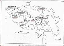
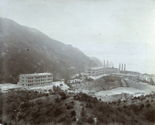
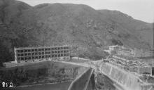
One of two reservoirs that appear on the 1889 map. They are labeled Sugar Works Reservoirs. Possibly built at the same time as the Sugar Refinery.
Was demolished about 1970 and used for housing estates and Taikoo Primary School.
Photos that show this place
 1889 |
 1910 |
 1929 |


Comments
The 1952 map is a good one to
The 1952 map is a good one to use for the outlines of the reservoirs in Quarry Bay.
Problems with the 1952 map
Hi David, yes, the 1952 map gives the correct location of the reservoir. But - for about a week now the 1952 won't appear on my computer (Microsoft Edge). I get the grid for the map and a small icon in the upper left corner, but the map (image) won't show. It works when I use Firefox. Could you please check it. Regards, Klaus
re: Problems with the 1952 map
It's a combination of:
For further explanation and a temporary work-around see http://www.agilepointnxblog.com/google-chrome-blocking-mixed-content-dow...
Thank you, it works now.
Thank you for your help, it works now.
re: Problems with the 1952 map
I've had good news from Tymon that hkmaps is now accessible using https, so there's no need to use the workaround any more.
https://www.hkmaps.hk/mapviewer.html