Everything tagged "boundary" | Gwulo: Old Hong Kong

Everything tagged "boundary"

The Anglo-Chinese Boundary 1898

Guest author Klaus Liphard describes how the boundary between the New Territories and China was created in the 1890s.


Introduction

At the end of the 19th century, the Chinese Qing Empire was weak. This was utilized by foreign powers - France, Germany, Russia, and also Great Britain - to force China to lease territories to them.

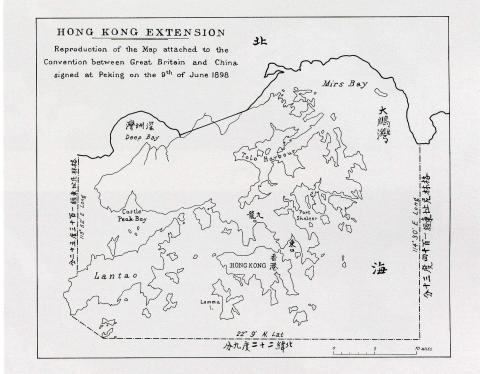
Britain forced China into The Convention Between Great Britain and China Respecting an Extension of Hong Kong Territory, also known as the Second Convention of Peking, which leased the New Territories to Britain for 99 years. The Convention was signed on 9 June 1898 in Peking (Beijing) and became effective on July 1st, 1898. This short convention (the English text is only one and a half pages) included a map showing the new boundary.

Map of Hong Kong in The Convention for the Extension of Hong Kong Territory in 1898
Map of Hong Kong in The Convention for the Extension of Hong Kong Territory
in 1898, by Klaus


This map had a small scale only. The eastern end of the boundary on land was at Starling Inlet (Mirs Bay), and the western one at Deep Bay. Between these two end points, a straight line was drawn. The exact course of the boundary had to be negotiated by

First marker of the The Anglo-Chinese Boundary 1898 [1899- ]

Date Place completed: 
1899-03-17

See the story behind at The Anglo Chinese Boundary 1898

Mr. Stewart Lockhart's report:

The Northern Boundary commences at the point of high water-mark in Mirs Bay where the meridian of 114°.30' East cuts the land and follows that high water-mark to the point marked with a peg immediately to the West of the market town locally known as Tung Wo Hü and sometimes called Shat'aukok.

Marker set in the morning of the 17th March, 1899.

Arrival of Commissioner at Sham Chun

Photo taken on the 17th or 18th March, 1899.

For the story behind this photo see: The Anglo Chinese Boundary 1898

Date picture taken (to nearest decade for older photos): 
1899

The Delimitation Commissioner at the ferry near Sham Chun.

Photo taken on the 17th or 18th March, 1899.

For the story behind this photo see: The Anglo Chinese Boundary 1898

Date picture taken (to nearest decade for older photos): 
1899

The Delimitation Commission at the source of the Sham Chun River.

Photo taken on the 17th March, 1899.

For the story behind this photo see: The Anglo Chinese Boundary 1898


Date picture taken (to nearest decade for older photos): 
1899

The Delimitation Commission ascending the Gap from Starling Inlet.

Photo taken in the morning of the 17th March, 1899.

For the story behind this photo see: The Anglo Chinese Boundary 1898

Date picture taken (to nearest decade for older photos): 
1899

Mr Stewart Lockhart, the British Commissioner, and Mr Wong, the Chinese Commissioner, fixing the first boundary mark in the shore at Starling Inlet.

Photo taken in the morning of the 17th March, 1899.

For the story behind this photo see: The Anglo Chinese Boundary 1898

Date picture taken (to nearest decade for older photos): 
1899

Group of the British and Chinese Commissioners, taken at Sham Chun.

The photo shows WONG TS’ÜN-SHIN (王存善) on the right and JAMES HALDANE STEWART LOCKHART second from right in the front row.

Quite likely the European standing between Lockhart and Wong is Mr. ROBERT DALY ORMSBY, Director of Public Works.

The photo was taken on the 17th or 18th March, 1899.

For the story behind this photo see: The Anglo Chinese Boundary 1898

Date picture taken (to nearest decade for older photos): 
1899

View of the Sham Chun River (The hills are on British Territory, the valley on chinese Territory)

For the story behind this photo see: The Anglo Chinese Boundary 1898

Date picture taken (to nearest decade for older photos): 
1899

Pages

Subscribe to Everything tagged "boundary"