Articles tagged "boundary" | Gwulo: Old Hong Kong

Articles tagged "boundary"

The Anglo-Chinese Boundary 1898

Guest author Klaus Liphard describes how the boundary between the New Territories and China was created in the 1890s.


Introduction

At the end of the 19th century, the Chinese Qing Empire was weak. This was utilized by foreign powers - France, Germany, Russia, and also Great Britain - to force China to lease territories to them.

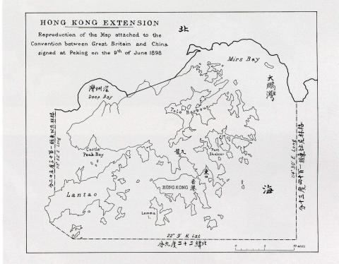
Britain forced China into The Convention Between Great Britain and China Respecting an Extension of Hong Kong Territory, also known as the Second Convention of Peking, which leased the New Territories to Britain for 99 years. The Convention was signed on 9 June 1898 in Peking (Beijing) and became effective on July 1st, 1898. This short convention (the English text is only one and a half pages) included a map showing the new boundary.

Map of Hong Kong in The Convention for the Extension of Hong Kong Territory in 1898
Map of Hong Kong in The Convention for the Extension of Hong Kong Territory
in 1898, by Klaus


This map had a small scale only. The eastern end of the boundary on land was at Starling Inlet (Mirs Bay), and the western one at Deep Bay. Between these two end points, a straight line was drawn. The exact course of the boundary had to be negotiated by

Subscribe to Articles tagged "boundary"