Everything tagged "Wan Chai" | Gwulo: Old Hong Kong

Everything tagged "Wan Chai"

Central harbourfront (once upon a time), 2016

Standing under the bridge by Lung Wo Road 龍和道 and Man Yiu Street 民耀街 (or thereabouts), looking at what used to be the Central waterside. From right, the AIA Tower, Hutchison House, Bank of America Tower... Hopewell Centre 合和中心 somewhere in the background, Prince of Wales building, Citic Tower... Central Plaza.

Date picture taken (to nearest decade for older photos): 
2016

Tiger Balm Garden, Haw Par Mansion -1.jpg

Date picture taken (to nearest decade for older photos): 
1957

The Haw Par Mansion and its adjoining landscaped garden, occupying eight acres of land on the rocky slopes of Tai Hang, Wan Chai was completed in 1936. That year, the Tiger Balm Garden was opened for public enjoyment and, prior to being demolished in 2004, became part of the collective memories of generations of visitors and Hong Kong residents.

Lockhart Rd - Lily Bar - Pussy Cat Bar

Hello, I'm new to the group so if I mess up, please forgive me.

I'm after some info for a novel I'm writing. To keep facts straight I need to know when the Lily Bar changed to The Old China Hand & also when The Pussy Cat builing was demolished. Can anyone help? The Pussy Cat was still there in 1984 but gone by 2011.

Also, and this is a long shot, does anyone have a photo of the painting of Lily mentioned in this blurb. I picked up this info whislt having a few pints in the OCH in 2011

.Many thanks

Tony

Wanchai_Morrison_Hill_1952

Text on Flickr:

Date picture taken (to nearest decade for older photos): 
1952

Reclamation_Wanchai_1970

Date picture taken (to nearest decade for older photos): 
1970

Cropped from The view from the Peak early 70's Hong Kong (1)

Visible at the waterfront

right: Wanchai Ferry Pier

left: Fenwick Pier (second generation) - or, at least, construction of

DSCN9626.JPG

Date picture taken (to nearest decade for older photos): 
2016

The building was finished before the outbreak of war in 1941.

HONG KONG: 1950'S (view from the Peak 3)

View from the Peak onto Barker Road and Wan Chai. (Photo shigthly enhanced.)

Early 1950, see also https://gwulo.com/atom/30238.

Date picture taken (to nearest decade for older photos): 
1950

Looking east from the peak

Date picture taken (to nearest decade for older photos): 
1978

1920 Wan Chai and Kellett Island, Hong Kong. = 灣仔及奇力島

Text on Flickr:

Wan Chai and Kellett Island, Hong Kong, c.1920.

Date picture taken (to nearest decade for older photos): 
1920

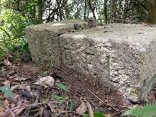
Ruins of housing on hillsides by WanChai Gap Rd./Green Trail

As I was walking up the first part of Wan Chai Green Trail from Kennedy Rd. and up towards Peak Rd. I noticed some ruins of old housing on the hill sides. What remains today are house foundations, terraces and some tile flooring. Most of this is now overgrown by dense vegetation.

I am curious if we know who lived there, and when the areas were cleared? It looks old, but my guess is probably not much more than 50 or 60 years. 

Any information about this is appreciated.

Allan

Pages

Subscribe to Everything tagged "Wan Chai"