Received via email
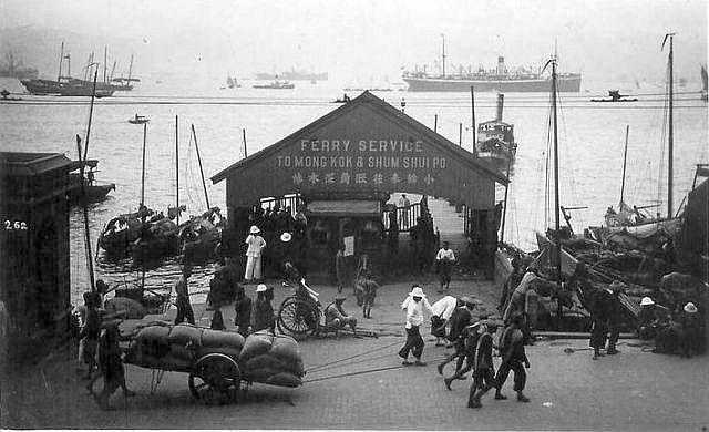
1920s Praya Mong Kok Ferry
Primary tabs

Submitted by Admin
Gallery:
Connections:
- 1920s Praya Mong Kok Ferry shows Place Western Market pier at Morrison Street / Connaught Road for ferries to Mong Kok & Sham Shui Po [????-????]


Comments
Dating and locating this photo
A cropped copy of this photo appears on page 62 of "A century of Hong Kong Island Roads and Streets" by Cheng Po-Hung, with the description:
We can see the tramlines' electric wires in this photo. The trams don't run along the section of Connaught Road near Gilman Street (they're back on Des Voeux Rd at that point), so I think we're right with the previous idea that the pier was in front of Western Market, based on the map and the Arthur Ball photo.
If Po-Hung got the location wrong, any ideas if the year 1925 is right? The only clue I can see is the presence of the Urinal building on the left of the photo. It doesn't appear in the other photo we have of this pier. So I assume this photo is the more recent - but which year?
MrB
Dating photo of the ferry pier
re: dating & locating
Here are a few more more ideas.
The curved tram tracks pinpoint the location - where the tram line turns from Connaught Road into Morrison Street, with Western market on the corner. This photo was probably taken from the market building. I'll guess this is the earliest photo, taken in 1924 or possibly even earlier, before the Yau Ma Tei Ferry Company started using the pier.
This comes next. The ferry company is in residence, but there is no latrine / urinal building to the left of the ferry, which helps with the date. On 16th May 1924, the government announced "[...] the Government proposes to erect a Public Urinal in Connaught Road immediately opposite to the Western Market." Then at the end of the year, point 111 in the Annual Report states "The removal of the Urinal at Connaught Road, Central, opposite the Western Market, was the result of negotiations with the proprietors of the New Queen's Hotel, the cost involved therby in the sum of $1,950.00 being borne by them."
Those two statements seem contradictory, but I'd guess that the small building in the first photo was a urinal, standing in front of the New Queen's Hotel. They objected to the interruption to their sea view (and probably the smell too!), and arranged with the government to move the urinal to the seafront in front of the Western Market. If that's true the second photo would have been taken between the arrival of the ferry company (1924), and the construction of the new urinal building (1924), ie it was taken in 1924.
Then there's the third photo, shown at the top of this page. The new urinal building is finished, so the date should be late 1924 or later.
Finally there is the Arthur Bell photo, where we can confirm the pier was in front of the Western Market, and we know the photo was taken in 1946.
It's still possible the ferry could have used a different pier after the war. The Arthur Bell photo shows the pier was damaged, and the single pitched roof of the earlier photos has gone. When the ferry service resumed, could it have been relocated to one of the nearby piers that was in better condition?
MrB
1920s Praya Mong Kok Ferry