Kai Tak Airport History | Gwulo: Old Hong Kong

Kai Tak Airport History

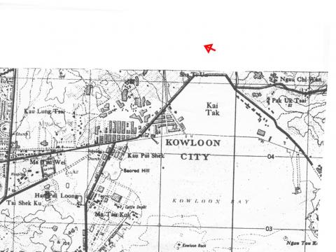
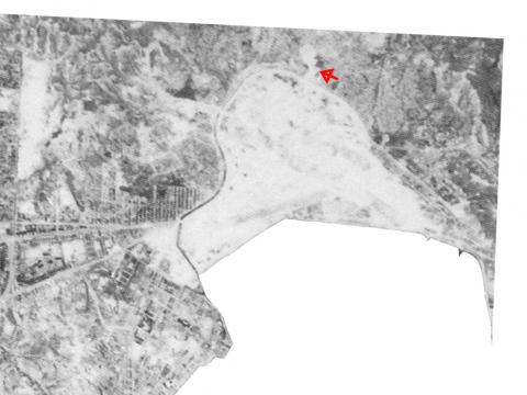
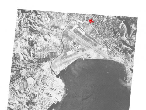
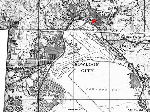
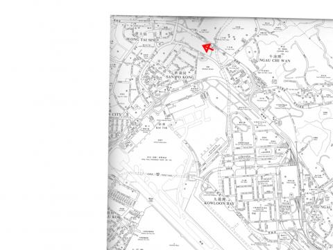
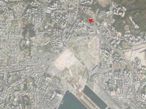
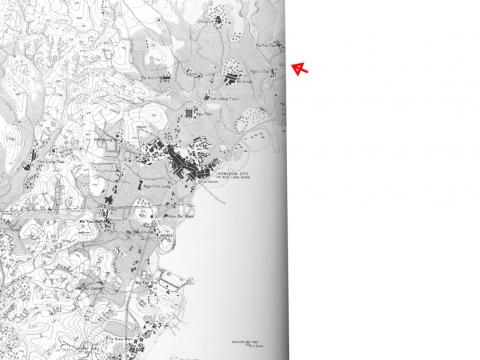
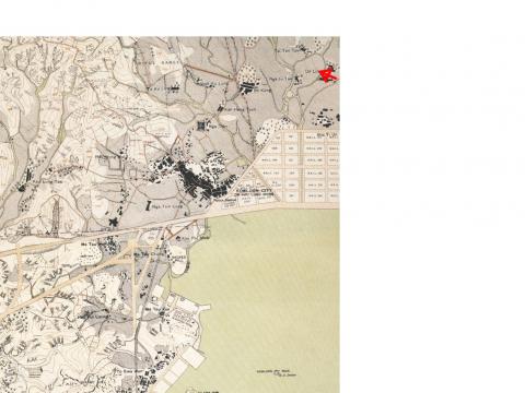
I was surprised at how far the old RAF Kai Tak hangar was from what I thought of as the airport area. So here is a sequence of maps and aerial photographs over the last 100 years or so, showing how the area has changed.

(The red arrow on each photo points to the hangar's location.)

1902 [1]

Kai Tak airport area

The area is mostly empty at this time, with just a few villages (the black areas are buildings), and not much in the way of roads. The main built-up area is Kowloon City. At the top left corner of that you should be able to see a triangle shape, pointing up to the top of a hill. That was the old wall that was part of the Chinese fortification in the area.

The Wright brothers wouldn't take to the air until the following year, so noone was thinking of airfields at this time. There had already been successful passenger flights though, with a passenger balloon taking off from Happy Valley in 1890. [2]

1924 [1]

Kai Tak airport area

In this 1924 map we can see several roads have been built, and the area that will become the airfield has already been reclaimed in the top right corner of the map. Oddly, it is marked out in a grid of streets, not runways. That's because the reclamation was carried out by the Kai Tak Investment Company, formed in 1922 by Mr. Ho Kai & Mr. Au Tak[3]. The goal was to build and sell housing on the new land, but they ran out money before the work could be finished.

1930 [4]

Kai Tak airport area

No big change in the shape of the land, but by 1930 the area Kai Tak is firmly in use as an airfield. There is a grass strip for light aircraft, and slipways for the larger seaplanes that would land and take off in Kowloon Bay. [2]

1944 [1]

Kai Tak airport area

This aerial photograph was taken by the US air force on one of the flights over Japanese-occupied Hong Kong. You can see the airfield is now much larger than it was in 1930. The expansion was conducted by the Japanese, with many of the Allied POW's used as labourers. When the work was complete, there were two concrete runways, one crossing the other.

I'd always believed that the expansion had been seawards, reclaiming land. There was some reclamation, especially in the southwest corner. But most of the new land appears to be in the northwest, extending the airfield further inland.

The black line curving around the western edge of the runway is the nullah, with a new road running along it's edge. Choi Hung Road still follows the same route today.

Just below the tip of the arrow is the hangar that we mentioned earlier, visible for the first time. Before the Japanese expansion, that area was nowhere near to the airfield. It suggests that the hangar was built during the expansion, and so was built by the Japanese.

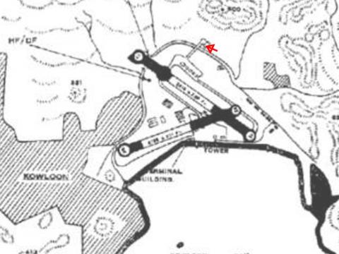
1948

Kai Tak airport area

Moddsey sent in this copy of a landing chart from the 1940s, showing the two runways mentioned earlier. He writes:

Not a very clear map but one can see the access road to the hangar.

Note the crossing runways with the longer main runway in a southeasterly/northwesterly direction and the secondary runway in a west-south-westerly/east-southeasterly direction.

The main runway in a SE/NW direction was designated as Runway 13/31 and the secondary as Runway 07/25.
 
If one is landing or taking off in a south-easterly direction, one would be landing or taking off on Runway 13 and conversely the other way round would be Runway 31. The designation of 13 refers to the physical alignment of the runway in relation to north which approximately equates to a bearing of 130 degrees.
 
Due to terrain, Runway 13 was used for landings and take-offs whilst Runway 31 was only used for landings; Runway 07 was only used for arriving aircraft whilst Runway 25 was only used by departing aircraft.
 
There is no information at hand to indicate when did the RAF hangar at Tai Hom become disused. My guess would have probably been in the late 1940s when Government needed space to accommodate the growing influx of refugees from the Mainland.
 
There were two road crossing points with barrriers and bells to halt road traffic. From recollection, one was located on Clearwater Bay Rd (today's Choi Hung Rd) near the present day Kai Tak Nullah in San Po Kong and the other on Ma Tau Wai Rd near the present day Kowloon City roundabout.
 
Having said all that, one has to remember that post-war Kai Tak also functioned as a seadrome with Sunderlands, Catalinas etc landing and taking off from Kowloon Bay. It was indeed an interesting era!

1954 [1]

Kai Tak airport area

No big changes to the layout. The hangar is still just across the road from the northern boundary of the airport, but was it still in use?

if you look closely you'll see two small white crosses on the sea below the end of the runway. Those are two seaplanes.

1957 [4]

Kai Tak airport area

I guess the hangar was no longer considered part of the airfield at this point, as the road from the airfield to the northeast boundary no longer lines up with the road that passes the hangar.

The Japanese runway layout is still in use, but not for much longer, as the big reclamation is underway to build the new runway. It was major news at the time, and made the first page of the 1955 Hong Kong Annual Report:

The year also saw the start of work on a $110,000,000 project to revolutionize Kai Tak Airport by the construction of a 7,200-ft runway on an artificial promontary reclaimed from the sea and projecting out into the waters of Kowloon Bay. In danger of being knocked off the international airline map by reason of its airport being too small and dengerous for the Comet and the larger conventional airliners, Hong Kong has now taken steps to keep itself firmly on the map. The airport project, when completed in 1958, will provide, for the first time since aviation started in the Colony, facilities for day and night operation all the year round.

1990 [1]

Kai Tak airport area

This is the area as it was when I arrived in 1989. The northwest boundary of the airport, Prince Edward Rd East, is not so far away from the northwest boundary of the original airfield in the 1920s. The area above that, San Po Kong, was an industrial area, except for a small area to the east which housed the Blackdown Barracks.

Most of the area between the original coastline and the runway has been reclaimed, leaving the foul-smelling nullah between the two.

2008

Kai Tak airport area

Here's how it looks today. Although Kai Tak Airport has been closed for almost ten years, the area is still awaiting redevelopment. The latest plans propose a mix of residential and hotel accomodation, a large stadium, and two new cruise-ship terminals.


As always, please leave a comment if you have any information or memories to add, or any corrections to make.

Regards, David

References:

[1] Maps and aerial photos from the 'Mapping Hong Kong' book
[2] Kai Tak Air Traffic Control
[3] Kai Tak Airport 1925-1998
[4] Maps from Map Library in Central Library
Tags: 

Comments

Oh yes, those barriers at the top of Run 13! When the bells broke the morning silence my 7 a.m. bus would stop allowing me to watch the airplane taxi across the road in front, make a U-turn and next take off. At other times, my bus would stop when a plane came in to land, or land from the southeast. Yes, no planes took off from the southeast on Runway 31. I can notice the spot being today's Choi Hung Road next to the nullah. Planes were using Runway 13 in 1957-58 when I frequently travelled that area. Around 1958-59, I started to see planes using the new runway built on reclaimed land. There was a nullah just northwest of where Clear Water Bay Road meets Kwun Tong Road at the foothill. My soccer ball fell into it and I watched it helplessly the next several days while it was rolling in the under-toe of a mini-cascade. They told me I had to get permission from the airport security before I could climb down to retrieve the ball. I didn't pursue it further - I had no long ladder. Wonder if that pigskin is still somewhere under some highrise condos.

In the early 1950s Runway 13 was extended in a northwest direction across Choi Hung Road and the Kai Tak Nullah to provide a longer take-off run for larger aircraft using the Airport. The extension across the nullah (the U-turn as oldtimer describes)and the beginning of the old runway in San Po Kong are marked by today's Tseuk Luk and Tai Shing Streets.

Thank Moddsey for pointing out the coordinates of the northwestern tip of Runway 13. Regarding MrB's comments about the location of the former airport hangar, I might have seen it with small planes inside to my left side after my bus had crossed Runway 13 and swung towards the southeast onto Kwun Tong Road. This would put it on the east side of Kwun Tong Road, northwest of Clear Water Bay Road, and northeast of the RAF Nissen huts which sat on the west side of Kwun Tong Road. It has been 50 years ago I travelled that way so my memory is a bit cloudy.

I've received some further clarifications:

Civilian / RAF airfields:

Prior to the closure of RAF Kai Tak in the 1970s, Kai Tak Airport and the airfield prior to it was divided into civilian and military use. The RAF had always occupied the eastern end of Kai Tak (next to today's Richland and Telford Gardens) whilst the civilian side was located at the western end. From the 1930s till 1941, the RAF and the Harbour Department (which controlled civiilan airport operations) both operated their own separate hangars.
In 1941 prior to the Japanese occupation, there were plans afoot by the authorities to expand Kai Tak Airfield and build paved runways. For such purpose, the RAF hangar located at the eastern end of the airfiled was dismantled in June 1941. During the war years the Japanese followed up with the British plans for expansion of Kai Tak and built the two paved crossing runways.
We've been sent a photo from the 1930s that shows the airfield at that time.
On Tony Banham's website I also saw these links to photos of several RAF buildings around Kowloon. Here's the entry for 17 Mar 2008 on Tony's site:
Local researcher Stephen Sin sent me this message and links. Although the majority of the architecture here is post war, there are some interesting pre-war details. Nice to see the RAF remembered! “My name is Stephen Sin living in Kowloon City. Recently I've been visiting Kwun Tong area & discovered some of the old RAF sites which are still here today at 2008.  I hope the pictures taken can be added to your website & tell people of these great history of RAF at Hong Kong:

Extension of runway 13

Moddsey, you mentioned that the runway was extended in the early 1950s, but the 1944 photo already seems to show a bridge over the nullah at that point, and the 1948 map also seems to have the runway bulging out over the road and nullah. Could it have been extended earlier than the 1950s, or was there a second round of extension in the 50s?

Oldtimer, it's a nice thought to think your football might still be there somewhere. We've received photos of the two landmarks Moddsey mentioned, but I guess they look a bit different from how you'd remember them!

Thanks to you both for your comments,

MrB

The aviation record indicates that the northwestern extension to Runway 13 in San Po Kong was completed in October 1950. The 1944 USAF aerial reconnaisance photo shows a worn track leading from the Kowloon Hills towards Choi Hung Rd and across the nullah. It is believed that the track was used by British POW labour to transport rubble for the building of the paved runways. The Hedda Morrison 1946 archive photo of Kai Tak taken from Kowloon Peak clearly shows the eroded track and the beginning of the paved runway that was confined within the Airport perimeter road.

Thank you MrB for the reply. I might have misled you. I was thinking of the other nullah, the one right across from the bus stop (see this photo).

This was the same city bus-stop where I spent my time waiting for the Good Hope school bus. Some mornings, us classmates would walk across the road to the east side to play soccer. The nullah there has a east-west orientation and thus ran towards the airport's Nissen huts in this photo; hence security clearance was needed to climb down to the nullah. One day while standing on the east side of the road I had sunny weather above me, but on the west side of the road it was pouring rain for a good half-minute. Another unforgetable moment.

[UPDATE: Giving links directly to the photos doesn't seem to work, so here's the longer way to get to them]

Here are the photos Moddsey refers to. It's worth zooming in on these - the amount of detail is quite something. To see them:

  • Visit the VIA website
  • In the "Search for: " box, type
        hedda kai tak
  • Click the 'Search' button
  • You should get 5 results
  • Click a photo to see its 'Full record'
  • On the Full record page, double click the image to open the viewer, which lets you zoom and pan around the image.

Two to note: 

  • Kai Tak seen from a distance, Kowloon Peninsula, Hong Kong
    This is the photo Moddsey was referring to. The bay at the end of the runway is clearly within the boundary of the road / nullah, so it seems the landing chart I've dated to 1948 was either inaccurate, or it was printed after the extension in 1950. On this photo we can also see the road from the runway to the hangar that started this conversation - but unfortunately the hangar itself is hidden from view by the hill in the foreground.
  • Kai Tak airfield, looking across eastern Kowloon to Lion Rock.
    Oldtimer, you should take a look at this one, as I think it's the same road you've described as your bus route. Also in the bottom left corner of this photo, the fence is broken by what looks to be a pillbox. It's not like any of the pillboxes around Hong Kong island, so I wonder if that was built by the Japanese?

MrB

Indeed, MrB, the photo you pointed out shows the same road in my bus route. The bottom right corner shows most likely the start of the Clear Water Bay road - that corner mansion with high stonecut-face wall, and the miscellaneous items on the ground on the south side (bottom edge of photo). The open (soccer) field and nullah must be somewhere to the right and behind the tall vegetations. The buildings inside the airport fence were quite different the way I remember them. It could be because at ground level I couldn't see them past the Nissen RAF huts. If this photo was taken prior to the 1950s, then the Nissen huts were located where these army trucks were parked. I don't remember seeing the pillbox in this photo. It was likely demolished by the mid-1950s. Thank you all, for such resourceful materials.

Hedda's photo of Kwan Tong Road by the airport [titled 'Kai Tak airfield, looking across eastern Kowloon to Lion Rock.', MrB] must have been taken from the hill side to the south of Choi Shek Lane, which now is being flattend. This photo is ringing more and more my memory bell. By 1957, the old pillbox on the foreground has been demolished replaced by a stop used by both the southbound city bus and the Good Hope School bus. This is the very spot I stood many times waiting for one bus or the other. Notice how narrow the start of Clear Water Bay Road was at that time. When they extended Kwan Tong Road, all those dozen boxes were moved to the right (east) side to be with the other metal frames. The reduced storage area remained for quite sometime as a small island. Downbound bus from the hill would circle clockwise around this island to the bus stop on the east side, then used the road by the big mansion (foreground) to travel uphill. Great photo, almost like being there again.

Hats off to Moddsey for finding these two photos, which he sent along with the following notes:

The first photo shows the RAF hangar at Tai Hom with a Spitfire undergoing maintenance in front of it.

The second photo captures the discussion that is taking place. It is an aerial shot of the northwestern end of Kai Tak probably taken after 1954 showing the:

  1. RAF aircraft parking apron to the north of the airport
  2. Extension to Runway 13 that was completed in 1950
  3. RAF hangar at Tai Hom and the access road leading to it
  4. Diamond Hill squatter area
  5. Choi Hung Rd and the nullah
  6. Worn track through Nga Tsin Wai Village that was used by British POW labour to build the paved runways (right of the extended runway)
  7. Sha Tin Pass Rd (left of the extension)
  8. Clearwater Bay Rd winding up Customs Pass and
  9. Good Hope School founded in 1954 (Oldtimer's school)

He also gave some more information about the hangar, which I've posted here.

MrB

We've been sent two more photos from those years:

  1. A nice photo of the approach to Runway 13 from over the Kowloon Hills. Note the runway had yet to be extended. The Tai Hom hangar is visible by the side of Clearwater Bay Rd on the top left of picture.
  2. In this photo the traffic has been stopped for a landing aircraft on Runway 13. Note the police post in the centre of Clearwater Bay Rd [now named Choi Hung Rd] beside the nullah.

Moddsey has sent in a couple of clippings from the Hong Kong News, the english-language newspaper published by the Japanese during the occupation. We're hoping to put a date to the start of the work to enlarge the airfield and lay the paved runways.

The first two are from 26 June and 19 August 1942, and are titled "Kowloon City removals time limit" and "Compensation to Kai Tak residents" respectively. They relate to the clearance of several built-up areas in the 1930 map, to make way for the enlargement of the airfield.

The third clipping is "Work on Kai Tak Airfield - Breaking the sod ceremony", dated 11 September 1942. This indicates that work on the enlargement would begin on September 15, starting with 800 POWs (Prisoners of War) as labourers. By October 1 they say 4,000 workers would be employed at the site, but they don't make it clear if all would be POWs, or there would also be local residents working as labourers.

Though the official start date was September, Tom Forsyth's diary shows that POWs were already working there in June:

June 15th 42

120 men went on a working party to Kai Tak to enlarge the airport there. It is on the mainland. [At this time, Tom Forsyth was imprisoned in the North Point POW camp. MrB] They carried a bun for mid-day meal.

June 20th 42

I was one of a large party who went out to the Kai Tak airfield on the Kowloon side, worked with pick and shovel and handled crushed stone, and big bags of cement. Just before we left to come back we were served with Zooki, beans cooked up with sugar. They are small and black and taste like a pea. Not accustomed to anything sweet for so long made some of the boys sick. Very tired tonight.

So it looks as though the work began somewhere in the period June - September 1942.

It's not clear when the work was finished, but the 'Ernie's story' website notes that the POWs did their best to limit any benefits the Japanese would receive from the POWs' work:

Even though the Canadians had no choice but to help the Japanese build Kai Tak, they found a way to sabotage it by putting too much sand in the concrete which made it brittle.

The first Japanese aircraft to use the runway, a large fighter filled with dignitaries, crashed on landing. The Japanese engineer in charge of the project was decapitated. It was a sad victory in a long defeat. (The Valour and the Horror, p. 44)

MrB

Work on the enlargement of Kai Tak also involved the dismantling of the walls of Kowloon Walled City and using rubble from the Sacred Hill of Sung Wong Toi. To the west of Kai Tak in a park in Ma Tau Wai stands today part of the original boulder inscribed with the Chinese characters of 'Sung Wong Toi' that used to be located on top of Sacred Hill.

The sabotage efforts of the POWs did cause concerns after the Japanese surrender as no one knew the actual strength capability of the runways and where the concrete was likely to fail. The RAF Airfield Constuction Units that arrived in September 1945 spared no time in making Kai Tak operational again and ready to handle larger aircraft e.g. DC-3s.

A 1945-1946 photo archive of Kai Tak of HMS Nabcatcher that shared the aerodrome with the RAF and the civil authorities is available through this link: http://www.royalnavyresearcharchive.org.uk/MONABS/KT_Album.htm

To add to Moddsey's comments, here are two photos of the original boulder [1, 2], and a Wikipedia article with more information.

There are several POW diaries that mention the work at Kai Tak.

Harry Atkinson:

WHAT TYPE OF WORK WAS IT?

Well by the time I got out to work they had finished building the runway and we were cutting down a hill , they wanted to extend the airport into this hill and the Chinese ceremonial cemetery hill and they couldn’t get the Chinese to work on it because it was full of people’s burial vaults.  And we started with little carts on a narrow gauge railway – a 4 wheel cart, we loaded it up and shoveled dirt into it and pushed it down to the end and dumped it.  As we got the hill cut down and further out the slope got steeper and longer and at the end of it it had blocks to stop the cart and we were supposed to have it go down under control well 4 men pushing the cart and holding it back, sometimes it would slip unnecessarily and we let the cart go and it hit the bottom and dump it.   But our officers didn’t work.   And I’ll always remember Len Corrigan , Lieutenant Corrigan from Swift Current , he removed his officer’s designation and he and Blackwood and a couple of others dressed as privates and always went to work.  I was in his work gang one day and he said “look, you fellas that don’t feel like it, sit and rest, you watch for the guard coming around the curve”, and whenever the guards started, they would call and we would get back to work.   But Corrigan did most of the shoveling in that cart.  He was a damn good officer.  He was a re-enforcement officer – he joined us when we came back from Jamaica.

HOW MANY HOURS WOULD YOU WORK ON THE Kai Tak AIRPORT?

Well recollection wise we would get up at 5-530 and have breakfast – a bowl of rice and a way down to the Ferry and away around the harbor to Kai Tak and work, we would be back at camp at 6:30, 7:00 at night have your supper and go to bed.  And you’re up the next morning.

Thomas Smith Forsyth:

Interviewer: After a number of weeks the Canadians were moved to Sham Shui Po prison camp. Do you remember what the, were the conditions any different there at Sham Shui Po?

Well, that's when the, the work party started. They had to work on the Kai Tak airport and it was miserable work. We were supposed to be mixing concrete and laying it down and doing all with, it was just pick and shovel work.

Interviewer: Were you men still fed the same amount of food?

We were supposed to get a bun, but then again the flour had, had been exposed, there was, had been insects in the flour, and it was a miserable poor diet.

Interviewer: So on that diet of three bowls of rice, you men were expected to do heavy manual labour out in the Kai Tak airport.

Yes we were, we were. Absolutely, we were.

Bernard Castonguay:

Interviewer: During that period of time, the men were expected to work. What do you remember about the work that you prisoners were expected?

Ya we were getting up in the morning at four, four thirty, every morning. And we had to walk through Kowloon to go to the ferry which is about two miles I think, to walk. And as we walk on the street every morning we saw corpses here and there. Chinese, die from lack of food. And we saw these trucks painted in green picking up the bodies and throwing them in like garbage. And we got on the ferry every morning to go to Kai Tak Airport. And we had to move a mountain to in the sea in order to enlarge the Kai Tak Airport. It was in the hot sun. We had a G-string, nothing on the head. And it happened a few times, too many times that we didn't have any breakfast or we didn't have any dinner. Imagine, and we didn't have enough to eat and yet they were not giving us our meal.

Garfield Lowe:

They took us across to the mainland and we had to work on extending the runway on the Kai Tak Airport air strip. What we had was a pole across our shoulder and there would be two baskets, and one on each end, hanging from each end of the pole, and they’d fill them with dirt from the mountainside and we’d carry them down and dump them where they wanted it and then go back for more. It kind of knocked hell right out of their health.

John McGee:

Interviewer: What happens next?

Well from when we finally got down to the harbour, they took us to, our camp was camp Sham Shui Po, then we did the walk from Kowloon to Sham Shui Po. That was the eight mile march we, and we did it so many times during the, after we were in the, on the way to (inaudible) Kai Tak airport. I'm sure everybody's heard about the, we built the, we did the groundwork for it. There was two mountains and they took 1,800 of us out there and an officer got up on top of the back of the truck and they shouted out to us in Japanese, and then the little guy had to interpret it and he said that we are going to take those two mountains and dump them in the ocean. Well that was our laugh for the day, you know, who the hell is... and 18 months later it was as flat as that table top. We had carried it on our backs and dumped it in the ocean.

Interviewer: So your march you were always carrying heavy...

Yeah, we had a big, long bamboo pole, one guy in the front and one guy in back and the bag of rice, rice bag and they throw three and a half, two and a half shovels of dirt on this bag and there were strings from end, like this and then we'd put a bamboo pole through it, put them on our, and march, dump them in the ocean, march back. And we were alright as long as we kept moving but if we stopped...


After the Japanese surrendered, there were still POWs working at the airport - but this time the prisoners were the Japanese themselves. The HMS Nabcatcher site mentions them, as well as general conditions around Kai Tak and Hong Kong immediately after the end of the war. Two good examples from that site are the memories of Charles Davidson and E.C. 'Mac' McCarthy.

MrB

The 'Walk The Talk' site has a good article about Sir Kai Ho Kai, the source of the "Kai" in Kai Tak.

MrB

You may find these books good companion:

The Squadrons Of The Fleet Air Arm        0 85130 223 8

The Squadrons Of The Royal Air Force      0 85130 083 9

Action Stations Overseas                         1 85260 319 4

Short Sunderland in World War II              1 85310 429 9

Sunderland Squadrons of World War II      1 84176 024 2

Hawker Hunter in Action                           0 89747 273 X

Hawker Hunter in Color                            0 89747 181 4

Airport Of The Nine Dragons Kai Tak          0 9586746 0 4

Kai Tak, A History of Aviation in Hong Kong - Government Information Services

The Life And Times Of Sir Kai Ho Kai        962 201 873 4

Enjoy

isdl

Hi there,

You folks might like to take a look at this despite the site is produced in Chinese. It showed photos of a recent dig/survey in last April at Kai Tai. It was in some Chinese newspapers earlier last week. I cannot verify if it's in SCMP or not.

The site also have older reference photos and maps.

Enjoy.

T

http://www.hiking.com.hk/discus/messages/59/51326.html?1211201024

The remnants of the pier could be the Kowloon City Market Landing Place. Cultural and historical references to Kowloon City and Kai Tak can be found in this link:

http://www.epd.gov.hk/eia/register/report/eiareport/eia_0592001/12-3.pdf

Thanks to Isdl, T, and Moddsey for the links. I've just borrowed a copy of ' The Life And Times Of Sir Kai Ho Kai' from the local library. He was an interesting man, and it's a good read about Hong Kong in the late nineteenth century.

The document Moddsey links to refers to old photos of the area. You can see those photos here.

MrB

A few more odds and ends:

We've been sent this clipping from the SCMP, describing the conditions for POW labour at Kai Tak under the Japanese.

A reader also noted this photo gallery at the Civil Aviation Department website, which has several photos of old the old airport.

Finally here's the section from the book 'The life and times of Sir Kai Ho Kai' (see pg. 31) that describes his involvement with the airport:

Au Tak (1840-1920) was the proprietor of a furniture shop named Chiu Loong Tai, situated on Chiu Loong Street in the Central District. The street still exists, but not the shop. Besides furniture, imported sundry goods and photographic equipment were also sold at the shop. Au was one of Hong kong's earliest developers, the owner of houses on such prime sites in the Central District as Chiu Loong Street and On Lan Street.

In 1912, Ho Kai went into partnership with Au Tak to form a company to develop a piece of land formed by reclamation. It was planned to build something like a garden estate there with houses, recreation grounds etc., for private tenancy. For this venture, Ho kai sold his two town houses on West Terrace, for which he received $12,000 and took up residence at 45B Robinson Road. This house valued at $22,500 was bought for him by Madame Wu TingFang and Au Tak who paid $10,000 and $12,500 respectively.

The development company was formed with a capital of $1 million, divided into 50 shares of $20,000 each. It was hoped that Ho Kai would have been made managing director with a competent salary and be entitled to one share of the company free. But the venture was a failure, it had not taken off in the two remaining years of Ho kai's life and eventually went into liquidation in 1924, ten years after Ho Kai died.

The land, which was named Kai Tak Bund, after the two principal partners, was taken back by the government. In 1925, and American pilot, Harry Abbot, leased the land to start a flying school there. Abbot was said to have fought on the side of Sun Yat-Sen as a mercenary during the civil strives [sic] among the warlords in the early years of the Republic. At the opening of the school, everything went wrong. The mechanic who demonstrated a parachute jump was drowned after he dropped into the harbour instead of landing on the airfield.

For the next few years, the airfield was used by the Hong Kong Flying Club for the purpose of teaching people to fly an aeroplane, with facilities for members to enjoy weekend flying. The Royal Air Force and Royal Navy also used it as a base for their planes.

[...] For all that Ho kai had done for Hong Kong, no street or building had been named after him. He is remembered only as the kai of the old airport, which was build originally on his business venture, Kai Tak Bund. After [the airport's] demolition, Ho Kai and his friend Au Tak will be forgotten, unless housing estates to be developed on the site will still be named Kai Tak.

MrB

I witnessed the 1962 Hunter crash from our roof top at Diamond Hill when I was eleven years old. Using a pair of surplus binoculars I watched the four broke out for landing after passing onto the habour, the last plane did not reappear over the hill, puff of black smoke and later a HKAAF helicopter took off to the crash site. Only very small pisces could be found on the news the next day. Can anyone help me find out more about that crash in any sites? Also I can remember the black pill box near Tai Hom village Hangar at one time was used by a BBQ merchant as a place for storing his stocks. We also played soldiers among the surplus RAF vechicles at the junk yard near Clear Water Bay Road. Thanks, Steven

Does a search through the old newspapers turn up anything? eg a search for 'Hawker' or 'Hunter' in years 1962-63?

Broken Wings : Post War Royal Air Force Accidents by James Halley may have the answer if it was an RAF aircraft, 20 or 28 squadron may be. If it was an Fleet Air Arm aircraft then needs other references.

香港全紀錄 (卷二) 一九六零年 - 一九九七年 [Illustrated Chronicle of Hong Kong 1960-1997] by 陳昕 has an entry “military aircraft accident at Kai Tak airport happened on 28 December, 1962” but no further details.

The closest that I can trace is an accident at RAF Kai Tak involving a RAF 45 Sqn EE Canberra in August 1964.

The Hawker Hunter crash that is referred to would appear to be crash of a RAF 28 Squadron FGA Mk 9 (Registration XE535) on 28 December 1962 on Lion Rock Ridge twelve minutes after taking-off from Kai Tak. You may have to look up the local newspapers to find out more.

I was going to try searching the South China Morning Post but I am not sure they keep their archives that long ago and they also require subscription. In Wings over Hong Kong p.141, the exact cause of the accident was never determined. Thanks to everyone again and especially to Moddsey and Mrb for showing the aerial picture of northwestern end of Kai Tak which is the first time in a picture from all the books about Kai Tak that I can almost pick out our house on Main street at Diamond Hill. It brought back so many memories: movie studio, monastery (Chi-Lin temple), crematorium, cemetery (lots of funeral processions), dye factory, soy brewery, streams with little fishes, quarry (not in picture) which gave a continuous supply for the construction of the new runway. I remembered Centurion tanks guarded by Gurkha soldiers parked just inside the gate at the access road across the Tai Hom hangar just before HRM the Queen's Birthday parade on Nathan road. Because of the proximity of the RAF, I grew up watching the Vampires, Venoms, Hunters, Canberras, Neptunes and particulary exciting when the huge camouflaged Blackburn Beverly in shiny gloss paint took off! When the aircraft carrier visited, sometimes they landed all their planes onto Kai Tak for exercises, Buccaneers, Sea Vixens, Gannets etc., what a sight! I also had pictures on HMS Victorious and USS Coral Sea from my school's Aero club tour but I lost all the pictures when I immigrated to Canada, but thanks to sites like yours I can still reminisce about the past.

Typhoon, thanks for the reminiscences - it's always good to hear the stories behind the photos.

You can search through / look at several old newspapers online. See the link above. Unfortunately that doesn't include post-war copies of the SCMP, but one of our anonymous supporters has sent in a couple of relevant clippings and a photo:

Hawker crash
Hawker crash
Hunter & Spitfire


Some of Fred Evans' photos show the tanks loaded onto the train, heading to Kowloon for a parade, and then the parade itself.

1950s Fred Evans' photos

I stumbled on this photo. You can see the old runways on the left, complete with the 1950 extension across the road, then on the right the new runway extends out to sea.

Aren't those the good old days? People could walk across the runway to their destination. Today, with airport security and restrictions, it is more convenient to say goodbye to friends and relatives at a nearby hotel or coffee shop. Those tanks for the parade made a lot of dents and scratches on Nathan Road. It took several weeks for the road's surface to recover - I think helped by the passing vehicles.

There is a second website that shows photos of HMS Nabcatcher. Some are duplicates of photos on the site moddsey mentioned above, but there look to be some extras too, like this map of the airfield:

http://www.hms-vengeance.co.uk/nabsw.htm

More photos here:

http://www.hms-vengeance.co.uk/monabhk1.htm 

The last minute of the video, starting from 4:22, gives a good long-distance view of the old runways, and then moves in for a close-up of the terminal buildings and runway area:

Nice long view of 1950s Kai Tak and the old runways from Kowloon Peak. However, the clip of the former Passenger Terminal Building (PTB), Observation Deck and scene of passenger embarkation were added in later. The PTB was opened in November 1962.

Here is a magnificent shot of Customs Pass (not Smugglers as indicated) and the old Sai Kung Road (later renamed Clearwater Bay Road) surrounding Kai Tak Airfield from Kowloon Peak probably taken in the late 1930s or early 1940s. Note the civil hangar at the western end of the aerodrome and Shatin Pass Road that veers right from the apex of Sai Kung Road. Unfortunately, the lady in the photograph is blocking the view of the RAF hangar on the eastern side of the airfield.

See my flickr upload about the Longjin Bridge excavation in former Kai Tak Terminal building site.

http://www.flickr.com/photos/27747234@N04/3572841856/

I have enjoyed your 'before and after' shots on Flickr.

Lung Tsun Bridge from the 1890s.

1890s Kowloon City Landing Place


At the land extremity of the stone bridge was the Lung Tsun Pavilion (today's junction of Sa Po Road and Prince Edward Road East) which led to the South Gate entrance to Kowloon Walled City. At the seaward extremity of the bridge was a wooden pier (not in picture) for marine craft to berth alongside. The bridge and the wooden pier were removed for the land reclamation of Kai Tak in 1924 and 1942 respectively.


For those aviation buffs, a video in German of a Swissair CV-990 (Convair) making an approach to Kai Tak via Cheung Chau Island-Green Island-Stonecutters Island and over Kowloon can be seen here:

http://www.youtube.com/watch?v=6Z0boBiZi94&NR=1

I recently read a Chinese book on the history of Kai Tai and I am now interested in the history of the area. Where was the original shoreline of the Kowloon City area when Kowloon and New Territory became parts of the colony? How far was the Kowloon Wall City from the original shoreline? Where the shoreline when the Kai Tak company started land reclaimation to build residential housing? Was the nullah along side the Choi Hung road a natural river or a manmade channel? Is the industrial area in San Po Kong the original site of the first Kai Tak airport? The Japanese military forced POWs to level a hill and use the materials to reclaim more land and expand the airport. Where were that hill and new land reclaimed? The resettlement buildings in Lower Wong Tai Sin Estate were built in the 1950's. What were on that piece of land before the estate was built? Before WWII, there was a stone marker on a hill that was in honour of the last two emperors of Song Dynasty. The marker is called Song Wong Toi, literally the Terrace of the Song Kings. Where was that hill?

Hi Lawrence, Please refer to the 1902 map above. In the centre, there is a triangle that is linked to a square. Both shapes depict walls of the Kowloon Walled City. Immediately south of the walled city there was a densely populated street (Kowloon Street) that led to a pier (Lung Chun Pier 龍津埗頭). I believe the first site of the Kai Tak Airport is the northeastern part of the 1998 Kai Tak Airport , i.e. around the Concorde Road area. The present-day San Po Kong industrial area became part of the airport during Japanese occupation. The hill that was levelled by the Japanese was called Sacred Hill (see the 1930 map above). It is where the Sung Wong Toi rock was. The location is just east of the present-day Olympic Avenue. Which book did you read?

I remember hanging out in the restaurant of Kai Tak (before passing through customs and immigration) in the 1990s, but for the life of me can't remember the name. I had wood panneling or another type of brown interior and hadn't been remodeled in decades. Does anyone remember the name and know when it was built? I'm thinking it was either Tin Tin or the Seven Seas Restaurant, but am probably off on both. Thanks!

Is this it? : ) http://images3.jetphotos.net/img/1/7/4/9/92118_1046851947.jpg I think it had a different name in the 1980s, but cannot say for sure.

Yes, Tin Tin was one of the Chinese restaurants at Kai Tak Airport.

In the 1990s, it was situated at the eastern end of the Passenger Terminal Building after the buidling's final phase of expansion. The restaurant chain had not served Kai Tak previously.

Thanks for the image! I think the restaurant I was thinking of was "Windows on the World", which is off to the right in the photo.

Looking at this photo, there was a wide 'bridge', where the runway crossed the nullah that runs along Choi Hung Road:

Kai Tak

Then looking at Google's satellite view, it looks as though the 'bridge' is still there, where Tai Shing Street crosses the nullah.

Yes, the bridge is still there and Tai Shing Street was the location of the old main runway: http://gwulo.com/node/1832

Steven , just stumbled on your message - from some years ago now .

But the crash you saw was a Hawker Hunter piloted by my wife's uncle David. It was a very sad story as he left a young son Drew.

The Pilots sister Anne is well and now lives in Australia . His brother Bill my wifes father sadly died af years ago.

I'm interested if you receive this message to hear if you can recall anything else and what you are now doing .

Two images of microfilmed newsprint relating to the pilot's activities in December 1962 have been added to the "Photos" section

1962 Hawker Hunter Crash

1962 Hawker Hunter Crash

Message from Bob:

Purely by chance I bumped into this site which has pictures of Kai Tak in 1945

This website  provides two excellent overhead photos of Kai Tak Aerodrome from pre-1941.

See here for the view of the civilian hangar, slipway and pontoon and here

for the view of the Kai Tak Reclamation (Bund), Kowloon City Police Station (at bottom), the civilian hangar (at centre), RAF hangar, slipway and buildings (far distance) and Sai Kung Road traversing Kowloon City.


The Old RAF HQ Buildings in Choi Hung are now occupied by the Academy of Visual Arts, shown, rather confusingly on Centamap, under their old title "The HK Police Detective Training School".

The entrance at the top of a rather imposing granite staircase, is topped by the AVA's logo, but if you visit, look closely under their logo and there in bas-relief, is the RAF Crest complete with "Per Ardua ad Astra".

Officials at the AVA would prefer you write/phone them before going there but if you arrive without norice and plead "Father/Grandfather served here etc etc" you can usually be allowed to take a look round!

I would have liked to input a picture but I'm afraid I couldn't cope with the instructions! Is there not a simpler method of uploading pictures?

Hi, that sounds like the Officers' Mess Building. We've got a few photos of it at: http://gwulo.com/node/7612, but any more you can add will be welcome. For starters just do these four steps:

  1. Click Create Image. Then on the next screen...
  2. Title: <Type in a few words to describe the photo>
  3. Image: <Choose the JPG / JPEG photo file on your hard disk that you want to upload>
  4. Scroll down, and click the "Save" button at the bottom of the screen

And the photo will be uploaded for all to see.

Regards, David

Pages