Everything tagged "pier" | Gwulo: Old Hong Kong

Everything tagged "pier"

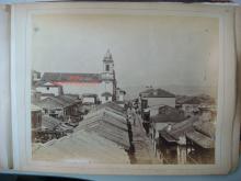
Wanchai View 1880s

Originally from the National Archives  Our Catalogue Reference: Part of CO 1069/447.

This image is part of the Colonial Office photographic collection held at The National Archives. Feel free to share it within the spirit of the Commons.

Shows probably the 1.000 foot Pier.

Date picture taken (to nearest decade for older photos): 
1885

Broadview_Court_Aberdeen

Date picture taken (to nearest decade for older photos): 
2015

From Wikimedia Commons.

The cubic building in front of Broadview Court is the Marine Police Aberdeen Base.

Brick Hill Marine Police Pier [1965- ]

Date Place completed: 
c.1965-01-01 (Month, Day are approximate)

From the Public Works Report for 1965:

At Brick Hill, Wong Chuk Hang, also on the south side of the Island, construction of a pier and an access road to it was completed. This pier will be used by Marine Police launches supervising Aberdeen harbour and neighbouring congested waters.

Tags: 

Wanchai-Tonnochy Road-new ferry pier

Date picture taken (to nearest decade for older photos): 
1949

Public Pier No. 17 - British Canton Line / Yuen On Steamship Co. Ltd [c.1924-c.1974]

Date Place completed: 
c.1924-01-01 (Year, Month, Day are approximate)
Date Place demolished: 
c.1974-12-31 (Year, Month, Day are approximate)

1920s photos show it with a semi-circular sign for the "British Canton Line". There's a good example at PH014_50-22 Gertrude Bass Warner photographs.

Maps from the 1930s / 40s, eg plates 3-5a and 3-5b in Mapping Hong Kong, label it as "Yuen On Steamship Co. Ltd, P.P. no. 17".

Tags: 

Praya Patrol

Date picture taken (to nearest decade for older photos): 
1946

Screen shot (at 7:40 min.) f

Hung Hom Ferry Pier (1st generation?) [c.1903-c.1963]

Date Place completed: 
c.1903-04-01 (Year, Month, Day are approximate)
Date Place demolished: 
c.1963-12-31 (Year, Month, Day are approximate)

I believe this was the first generation of ferry pier at Hung Hom, but please let me know if there was any earlier one. It was off Winslow Street, in front of the junction with Gillies Avenue.

Tags: 

Ma Tau Kok Road Refuse Boat Pier and Live Stock Landing [1936- ]

Date Place completed: 
c.1936-07-01 (Day is approximate)

At the end of Ma Tau Kok Road there are the remains of an old pier.

Looking at the 1952 map, it's the nearest pier to the old cattle depot, so I wonder if it is where cattle deliveries by sea were unloaded? [Update: It was a combined refuse boat pier and livestock landing pier. See comments below.]

1891年龍津橋 Lung Tsun Stone Bridge

Date picture taken (to nearest decade for older photos): 
1891

Tsing Yi Power Station (1970's)

Date picture taken (to nearest decade for older photos): 
1970

Uploaded with kind permission from Gammon Construction Limited, Hong Kong. The power station is one of their projects.

Pages

Subscribe to Everything tagged "pier"